Potash Road Moab, UtahThis travel adventure is a drive west from Moab on Potash Road (SR-279) along the northern side of the Colorado River to the Potash plant 15-miles west of Moab. We were in OK RV-Park & Canyonlands Stables 3310 Spanish Valley Drive 435-259-1400. We chose OK RV-Park & Canyonlands Stables because it was a Passport America Campground. Since we are Passport America Members we get a 1/2 price discount when staying in Passport America Parks. We paid $15.50 a night for full-hookup.
There are multiple commercial campgrounds in Moab. All of them appear to be good or at least adequate------no slums anyway. We decided to stay in OK RV-Park & Canyonlands Stables 3310 Spanish Valley Drive 435-259-1400 because it was a PPA park thus 1/2 price. Even at half price it was $15.50 per-night for FHU with 30/30 amps and cable included. Most RV-Parks in the area are going to be around $25 plus a stiff tax. This park had some shade so we picked it but the nice Spanish Trail RV-Park has nice shade as well and both are within a mile of each other. All of the parks in Moab appear to have gravel interior roads and sites. Since we are in Moab we need to know a little about it. Moab was first settled in 1855 by the Elk Mountain Mission of the Mormon Church. Less than 5-months later, three members of the party were killed by Indians and the settlers fled, abandoning their holdings. The next permanent settlers came in 1878. A Post office was established in 1879, and Moab was given its name, probably from a Biblical source. Finally in 1890 Grand County was created with Moab as the county seat. Cattle and sheep grazing were the main economic activities until the 1940's. Then, occasional mining turned to a boom as Moab became capital of the the western Uranium mining boom which lasted into the 1960's with a revival in the 1970's. Since the 1980's recreational pursuits have come to dominate Moab's economy. Long connected with Colorado River travel and freighting, this historic crossing has become the "Gateway" to some of Utah's most unique scenery with river activities on the Colorado River (rafting, kayaking and sightseeing), mountain biking, jeep and off road vehicle excursions into Canyon Country along with visiting Canyonlands & Arches National Parks attracting tourist to this region. We headed off in our Saturn to take this scenic drive along Potash Road.
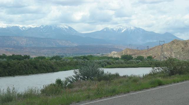
La Sal Mountains in western Colorado
This picture is of the La Sal Mountains that rise to the east of Moab. We are on Potash Road which follows the river west of Moab. If you are visiting Moab one of the things you will have to do is take a 15-mile or so drive west on Potash Road. If you have a jeep or off road vehicle you can continue much further than 15-miles but we stopped after the road became gravel and too rough to comfortably travel on in our Saturn. Potash Road is a Scenic Drive complete with petroglyphs Potash road intersects with US-191 near the entrance to Arches National Park in case you are wondering how to locate it.
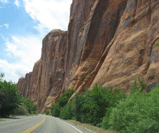
Sandstone cliff with Desert Varnish
This is the rock cliff along Potash Road that petroglyphs are drawn in. There are signs along the route that alert you to the petroglyphs Notice the desert varnish on the sandstone cliff wall.
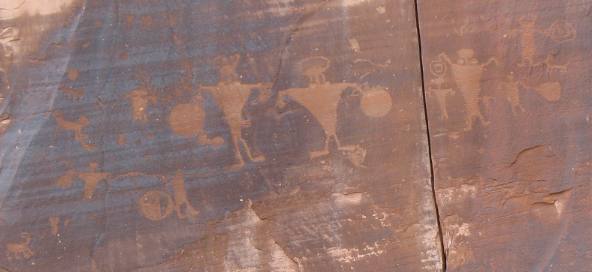
Petroglyphs on sandstone wall (potash road Moab, Utah)
This is an example of some of those petroglyphs We are not into petroglyphs or I would spend more time locating and examining them.
These are some of our other Travel Logs in this area: Arches NP-a ** Arches NP-b ** Arches NP-c ** Arches NP-d ** Arches NP-e ** Arches NP-f ** Arches NP-g Scenic Drive through Sandstone Cliffs ** Scenic Drive along Colorado River ** Scenic Drive through Canyon ** Historic Dewey Bridge Fruita, Colorado ** Scenic Drive along Potash Road in Moab ** Scenic Drive through Colorado River Canyon ** The John Wesley Powell Museum in Green River, Utah Sandstone Cliffs of Colorado National Monument ** Wingate Sandstone of Colorado National Monument ** Kayenta Caprock in Colorado National Monument Sandstone Tunnels in Colorado National Monument ** Fault in Colorado National Monument ** Grand Junction & Fruita, Colorado ** Volcanic Ash of Colorado NM Driving US-191 from Blanding to Moab, Utah ** Geology along US-191 south of Moab, Utah ** Moab, Utah visitor center flowers Until next time remember how good life is. Click here for more Utah travellogsUntil next time remember how good life is. More Utah AdventuresSome Key West Adventures ** More 2007 Travel Adventures
Mike & Joyce Hendrix
Mike & Joyce Hendrix who we are We hope you liked this page. If you do you might be interested in some of our other Travel Adventures: Mike & Joyce Hendrix's home page Travel Adventures by Year ** Travel Adventures by State ** Plants ** Marine-Boats ** Geology ** Exciting Drives ** Cute Signs ** RV Subjects ** Miscellaneous Subjects
We would love to hear from you......just put "info" in the place of "FAKE" in this address: FAKE@travellogs.us Until next time remember how good life is.
|
| ||
|
| |||
|
| |||
|
|