Buttes & MesasNatural Bridges National Monument on SR-95 30-miles east of BlandingMay 20, 2007. There are two commercial campgrounds in Blanding. We decided to stay in the one with some shade so we picked it but both RV-Parks were OK: $19.80 for FHU, gravel interior roads and sites. It is located on US 191 on the south side of town behind the shell station (hint, it is easy to find since Blanding is very small).
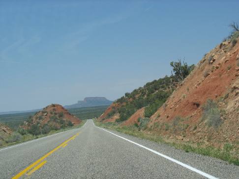
Butte on horizon
Sometimes the view from the highway in southeastern Utah is priceless. This is one of those moments. Geological features out west have names. Mountains or hills that havce flat tops can be called buttes, mesas or plateaus, depending on the size of the flat part at the top. The flat top hill in the distance is "smallish" so it is a butte. We spotted this butte when driving west on Utah SR-95 to Natural Bridges National Monument west of Blanding.
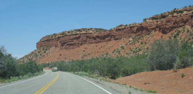
Sandstone mesa near Natural Bridges National Monument
At last we are nearing our destination. It seems like we should reach Natural Bridges just around this mesa.
The flat part of this "hill or mountain" is larger than the flat part of butte so instead of this being a butte it would be classified as a mesa.
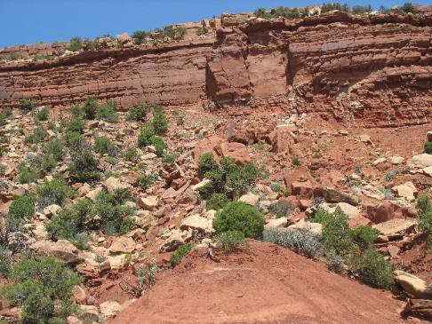
Mesa with sandstone sedimentary formation including a talus slope
The mesa is that flat top formation with steep sides.
The talus slope was created by sandstone rubble falling off the top and sides of this cliff.
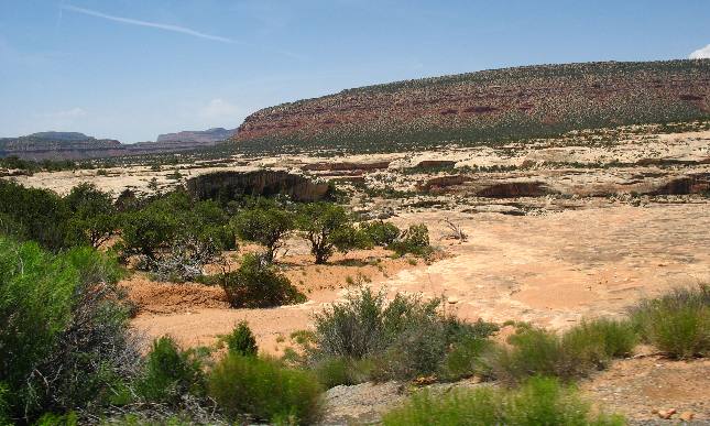
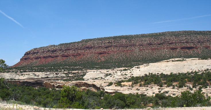
Mesas visible from Natural Bridges National Monument
The redish flat top formations in the background are all mesas. Mesas have flat tops and steep sides. They are not buttes because buttes have much smaller flat tops, typically not larger than the vertical heitht of the hill or mountain.
The light colored sandstone you see in the foreground is the sandstone formation that Natural Bridges is formed from.
Mesa visible from Natural Bridges National Monument
I am calling that a mesa but some folks may refer to it as a plateau. I am not sure exactly where the breaking point between a mesa and a plateau is.
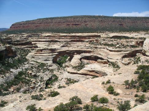
Look closely in the center of this picture you will see one of the natural bridges (arch) in Natural Bridges National Monument located around 35-miles west of Blanding, Utah.
Mesa fromed from Cutler Formation on top of the Cedar Mountain Sandstone at Natural Bridges National Monument
This is a good view of the "Cutler Formation" that was laid down on top of the pale colored Cedar Mountain Sandstone. The Cutler Formation consists of Shales and mudstone laid down from 240 million to 280 million years ago. Remember that the Cutler Formation is YOUNGER sedimentary rocks than the Cedar Mountain Sandstone that it rests on. Some folks may consider that a plateau instead of a mesa. In western jargon a butte is a small flat-topped hill with steep sides. A mesa is a "medium sized" flat-topped, steep sided mountain or hill. In other words a mesa is a butte only larger. A plateau is a really big mesa. OK, that is the distinction and I am sure there is a certain mathematical formula to decide which is which in a purely scientific definition. However, out west the distinction is blurred by what folks have called each particular formation. In other words some "technical" mesas have names that contain butte and so it goes. So just a warning, some of these formations may have names that do not fit the technical definition.
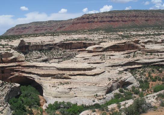
From Natural Bridges National Monument we see a mesa in the background
I am calling that formation in the background a mesa but it may be a plateau since I am not sure of the technical size break between the two geological formation. One thing I am certain of, it is larger than a butte. Joyce took this picture in Natural Bridges National Monument. That is one of the "natural bridges" or arches in the bottom left side of this picture. This particular Natural Bridge is called the Kachina Bridge. The Kachina Bridge was named for the Hopi (Indians) kachina spirits.
Mesa or butte in the background with sandstone formations visible in the foreground
That is a butte or mesa in the background with the flat top. If it is a butte, it is a big butte, if it is a mesa it is a small mesa. I think a butte has a top smaller than the vertical size of the mountain so using this definition this might be a mesa.
That is Cedar Mesa Sandstone exposed in Natural Bridges National Monument.
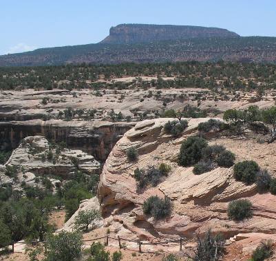
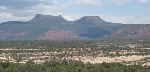
Bears Ears Buttes visible from Natural Bridges National Monument
These two prominent buttes in the distance are called the Bears Ears. Several native American groups including the Navajos, Utes, and Pueblos consider this area sacred. The Bears Ears can be seen from as far east as Mesa Verde National Park in southwestern Colorado and as far south as Monument Valley in Arizona. To say these buttes are and were important landmarks for travelers in the Four Corners region would be an understatement.
If you liked this Travel Adventure you might like one of these: Goosenecks on the San Juan River southern Utah
Click here for more Utah Travel Adventures
More Utah AdventuresPlants Trees and Flowers ** More 2007 Travel Adventures
Mike & Joyce Hendrix
Mike & Joyce Hendrix who we are We hope you liked this page. If you do you might be interested in some of our other Travel Adventures: Mike & Joyce Hendrix's home page Travel Adventures by Year ** Travel Adventures by State ** Plants ** Marine-Boats ** Geology ** Exciting Drives ** Cute Signs ** RV Subjects ** Miscellaneous Subjects
We would love to hear from you......just put "info" in the place of "FAKE" in this address: FAKE@travellogs.us Until next time remember how good life is.
|
| ||
|
| |||
|
| |||
|
|