|
I-10 across southern Arizona and New Mexico Places Visited: Sunday, June 12: Beaudry RV Resort Tucson, Arizona: $15-(summer rate) 50amp-full hookup paved interior roads with gravel sites. N32° 9.664' W110° 55.566' As we rolled across the Colorado River into Arizona it was time to reflect. While California interstates and highways are in abysmal shape the roadsides and public areas are extremely clean and free of litter. Crossing the river into Arizona brought both observations home in spades. Immediately upon entering Arizona I-10 smoothed out and my teeth began to reseat. However, the Arizona litter hits you like a ton of bricks. Weather along the Pacific Coast is utterly divine. We didn't run our air conditioner the entire time we were on the coast. Now that is how to spend the summer. On the other hand the Pacific Ocean is cold as ice, I guess you can't have it all. I am still having a hard time dealing with citrus growing in Fresno, California. For comparison that is like growing citrus in Norfolk, Virginia----they are both located along 36-degrees north latitude. Like I said, that is really difficult to comprehend. Haas Avocados are available everywhere and they are soooooo good. Yet Wendy's value menu that has 99-cent burgers and such throughout the country isn't a VALUE in California where the same items are $1.29. I am still having difficulty believing that we saw hamburgers on menus for $14-------not at Wendy's but in mom & pop cafe's. These weren't hamburgers in fancy places either just run of the mill joints. At first we thought it was a joke but it wasn't. As soon as we crossed the Colorado River this morning we began to climb out of the valley. Everyone knows that water flows down hill ---------- and the water flowing in the Colorado River is at the bottom of that hill. We climb and climb, not a hard climb but none the less the climb from the Colorado River was a thousand or more feet.
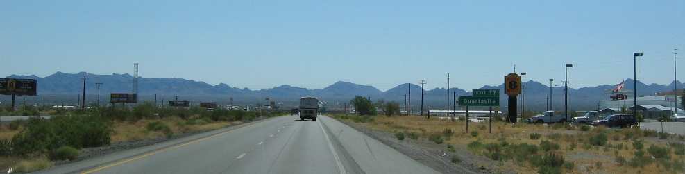
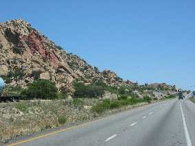
Quartzite, Arizona as seen from I-10 east bound
Twelve miles from the river we pass the infamous town of Quartzite, Arizona. It wasn't anything like we had imagined. It actually had permanent structures and RV-Parks with utility hookups. Why is it that when we finally see some places we have heard about for years it doesn't look like our mental picture? We kept climbing as we put Quartzite in our rear view mirror. I don't really know when we stopped climbing but around mile marker 50 we passed through what appeared to be a basin. It amazes us is that we can recognize basins. A few short years ago a basin was something old timers used to wash their hands in. Desolate desert region of southern Arizona along I-10
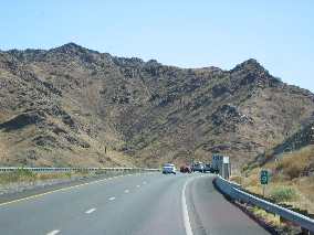
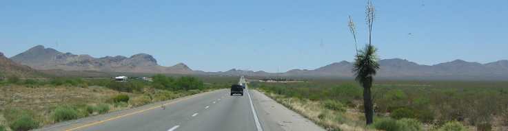
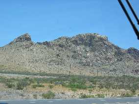
I-10 traverses a desolate mountainous desert region.
Desolate desert region of southern Arizona along I-10
I-10 traverses a desolate mountainous desert region. We normally stay at Voyager RV-Park when in Tucson however, we decided to give Beaudry RV-Resort a try with their attractive $14 rate for 50-amp full hookup sites and were not disappointed. The $14 even included free breakfast for us Monday morning and a free USA Today newspaper. I am impressed, we will probably stop here again. Monday, June 13: Coachlight Inn Motel & RV-Park Las Cruces, New Mexico I-10 exit 139. $13.30 with PPA 50-amp FHU gravel interior roads & spots within 2-miles of historic La Mesilla: N32° 17.489' W106° 48.441' We took advantage of the free breakfast offer at Beaudry and are glad we did, it was first-class. After breakfast the sun was high enough in the sky that we could head east without it blinding me so off we went. I-10 across southern Arizona traverses a series of very old volcanic mountain ranges with interesting river valleys or basins separating them. Desolate desert region of southern Arizona along I-10
The shape and texture of these igneous rocks is one that we have seen before. They have the same texture as the rocks in Joshua Tree National Park in California.
Desolate desert region of southern Arizona along I-10
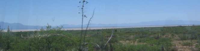
Salt flat in southern Arizona along I-10
For ages and ages the mountains on all sides of this basin have eroded depositing ever more material in the valley. Years ago this was an ancient lake bed. The water in this lake has long since evaporated leaving behind harsh mineral evaporate rich in salt. As you might imagine plants do not grow well in that salty environment. Some salt flats are perfectly flat while some have a gentle slope. While you can see the brown strip of salt flat in the distance you can also see the gentle slope leading to the salt flat.
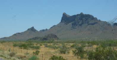
One of the desert basins in southern Arizona along I-10
This is a panorama of another basin. A basin is an area where water does not exit. This basin is surrounded by mountains. Water drains to the lowest part of this basin where it forms a lake that slowly evaporates.
Salt flat in southern Arizona along I-10
This is a more dramatic salt flat. Notice that it is much flatter. When the wind blows across this basin the fine deposits that comprise this salt flat reduce the visibility on I-10 to the point that highway officials actually close the interstate until visibility improves. This type of terrain is typical for 40 to 60 miles of west-central I-10 in New Mexico. We wanted to stop in the Travel Center in Benson, Arizona where we spent 4-nights in the parking lot earlier in this trip while our motorhome water pump was replaced and radiator cleaned. This time we only purchased some diesel. It is so nice to be out of California where diesel was $2.69 to $2.89. In Arizona diesel for automobiles and motorhomes was $2.37 over the road trucks was 6-cents more. Arizona is one of those states that put an extra charge on the 18-wheelers passing through the state in the form of that tax on diesel fuel. We generally avoid the normal pumps and head for the area where 18-wheelers fuel. That area isn't cramped for room and fuel pumps are designed for high flow unlike the low-flow pumps in the RV-areas. They also tend to have squeegees with long handles where I can wash the windshield. Washing a Class A Motorhome windshield is a difficult task to perform with a short handle squeegee. The Travel Center was still there and so was the parking lot. We didn't have any hankering to spend another night in that parking lot (4 was enough) so we headed back out to I-10 and pointed the motorhome east. Once on I-10 we were coasting down that big hill that had caused us to overheat when we were headed west. The hill plunges down to the San Pedro River that flows north into the United States from Mexico. There isn't any water in it now so it must flow only during the rainy season.
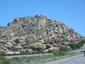
Remnant of volcanic mountian in southern Arizona along I-10
Continuing east I-10 continues through more volcanic mountains and classic basins trapped between them.
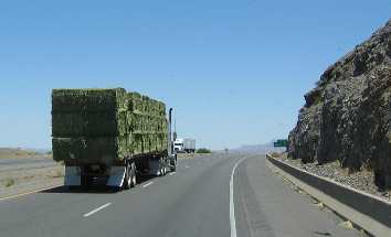
Hauling alfalfa east on I-10 through southern Arizona
18-wheelers loaded with alfalfa is as much of the western scene as the volcanic rocks.
Continental Divide around mm-49 on I-10 in New Mexico
Anyway, once we cross the San Pedro River near Benson, Arizona we start the climb out of that drainage area and don't really stop climbing until we get to the Continental Divide around mile marker 49 in New Mexico. When we cross the Continental Divide we have reached the elevation of 4,582' or something close to that. The change in elevation approaching the Continental Divide along I-10 is almost imperceptible but once on the eastern side we start the gradual decent into Las Cruces at 3,880 feet. Look closely at the picture. That is the continental divide at the top of this "hill". The Rio Grande River is still fairly high in elevation along here especially compared to the Colorado River back in Needles, California that was at only 350'.
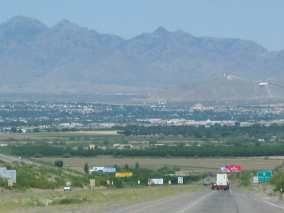
View of Las Cruces, New Mexico and the Rio Grande Valley with Organ Mountans in the background
As we near Las Cruces we began to see the huge irrigated pecan orchards Las Cruces is famous for. Then we get this view of Las Cruces. Las Cruces is spread out along the Rio Grande Valley with the Organ Mountains providing the backdrop. We always stay at the Coachlight Inn and RV-Park when in this area. There is nothing special about the place but it has 50-amps (a must in the summer) and is located about one-mile from historic La Mesilla.
Until next time remember how good life is. More New Mexico AdventuresAdventures by State ** More 2005 Travel Adventures
Mike & Joyce Hendrix
Mike & Joyce Hendrix who we are We hope you liked this page. If you do you might be interested in some of our other Travel Adventures: Mike & Joyce Hendrix's home page Travel Adventures by Year ** Travel Adventures by State ** Plants ** Marine-Boats ** Geology ** Exciting Drives ** Cute Signs ** RV Subjects ** Miscellaneous Subjects
We would love to hear from you......just put "info" in the place of "FAKE" in this address: FAKE@travellogs.us Until next time remember how good life is.
|
| ||
|
| |||
|
| |||
|
|