Mullan Road & Ft Benton, MontanaMullan Road & Ft Benton, MontanaJuly 21, 2007. We are staying in Dick's RV Park in Great Falls, Montana. It is a nice enough park with paved FHU sites & Cable for $27. They do charge extra for wifi but we found an open wifi signal in the park. There isn't a lot of choice in Great Falls, it is either Dick's or KOA and we avoid KOA if at all possible. Bottom line, we would recommend Dick's when stopping in Great Falls.
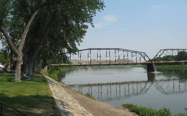
While our motorhome is located in Great Falls we headed to Fort Benton in our Saturn today. Fort Benton is located about 40-miles northeast of Great Falls. Ft Benton on the Missouri River
From 1860 until the railroad arrived in 1887, most of the freight for the northwestern U.S. and Canada was unloaded on this levee in Fort Benton. Fort Benton is one of those historic places that has not received the credit it deserves in the western expansion of this nation. Originally a trading post of the American Fur Company it became the northern most point of navigation on the Missouri River. The first steamboat from St. Louis arrived in 1859. Fort Benton boomed in the early 1860's as a point of entry to the newly discovered placer mines of western Montana. Supplies were freighted out of Fort Benton by means of ox teams and much profanity. One early observer stated; "Perhaps nowhere else were ever seen motlier crowds of doubed and feathered indians, bullskined-arrayed half-breed nobility, moccasined trappers, voyageurs, gold seekers and bull drivers...(sic)" When steamboats plied the Missouri in the 1800s, Fort Benton was the world's innermost port; waterfalls just up the river prevented further navigation. During the 30-years that steamboats regularly docked here the town bustled with the activity of merchants, traders, cowboys, American Indians, miners and adventurers. Ox teams hauled the freight from the levee in Ft Benton to far-away points. Wells Fargo coaches took miners to Helena for $25. From Ft. Benton Ox teams hauled westbound freight over the Mullan Road across the Continental Divide and into Wala Wala, Washington, where cargo could once again be placed on water craft and transported to the Pacific. Sometimes historically important things are overlooked in text books, in my opinion the MULLAN ROAD, is one of those places.
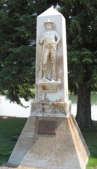
The Mullan Road connected Fort Benton on the Missouri River with Fort Walla Walla on the Columbia River. It was the first federal highway in the Northwest. Covered wagons, stage coaches and freighters used this route to the gold bonanzas in the mountains of Montana and Idaho. Branches led to Helena, Bannack and Virginia City. The main road continued on west through Missoula and up the Clark's Fork to Spokane, before turning south through the Palouse to the Columbia. Note that the Mullan Wagon Road is the connecting link that President Jefferson envisioned when he sent Lewis and Clark west with the Corps of Discovery in 1804. At a fraction of the cost of an interstate turnoff, Captain John Mullan constructed the 624-mile wagon road from 1855 to 1862 that linked Fort Benton to the head of navigation on the Columbia. Indian wars slowed him somewhat, but Mullan opened his route to travel in 1860, years ahead of the transcontinental railroads. The Mullan Road began at the levee here in Fort Benton and ended at Fort Walla Walla. The road's history has faded into forgotten lore, but it was a highway to empire, the fastest land-water route across the continent in its day. Travelers took 47 days on the road, but boarded steamboats at either end where comfort and pleasure promised a safe arrival at either terminus. This statue, along the levee in downtown Fort Benton, honors Captain John Mullan.
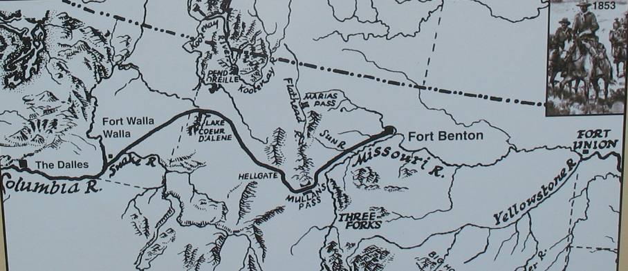
Map of Mullan Road
I thought it appropriate to include this map of the Mullan Road so that you can more easily understand the significance of this road in the early history and settlement of this segment of the North American Continent. Do understand that the Mullan Road traversed the Rocky Mountains and the Continental Divide as it connected these two river routes. The Mullan Road wasn't the only historic road with its genesis in Fort Benton. The Whoop-up Trail was just as important to to the early history of Canada. The Whoop-up Trail was a wagon road from Fort Benton to Canada.
Click here for more Montana Travel AdventuresUntil next time remember how good life is.
More Montana AdventuresSome Exciting Drives** More 2007 Travel Adventures
Mike & Joyce Hendrix
Mike & Joyce Hendrix who we are We hope you liked this page. If you do you might be interested in some of our other Travel Adventures: Mike & Joyce Hendrix's home page Travel Adventures by Year ** Travel Adventures by State ** Plants ** Marine-Boats ** Geology ** Exciting Drives ** Cute Signs ** RV Subjects ** Miscellaneous Subjects
We would love to hear from you......just put "info" in the place of "FAKE" in this address: FAKE@travellogs.us Until next time remember how good life is.
|
| ||

| |||
|
|
|||
|
| |||
|
|