|
Nebraska:
Valentine, Ft Niobrara National Wildlife Refuge Places Visited: Nebraska: Valentine, Ft Niobrara
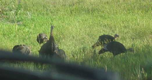
National Wildlife Refuge Saturday August, 21; Valentine Motel & RV-Park. Valentine, Nebraska: N42° 51.993': W100° 32.750' $22.50 gravel pad & interior roads full hookup 30/50-amps with cable TV & phone connection @ each site no extra charge. Still not fully recovered from last night we connected the Saturn to the motorhome and headed to Valentine, Nebraska. Valentine isn't on the Lewis & Clark trail but it does have Fort Niobrara National Wildlife Refuge located four miles east of town. Ft Niobrara is noted for its buffalo and elk herds. Turkey, burrowing owl, sharp-tailed grouse and prairie chicken are also present in the preserve. Large flock of wild turkey near Valentine, Nebraska
We had only been on the road for a few minutes when we spotted a group of mature turkey feeding near the highway. I slowed the motorhome so that we could take video. There was no traffic coming in either direction. They did not seem to be bothered by our presence as the motorhome approached at around 5-mph. I was not able to count all of them but did count to 14. I think that is the largest group of wild turkey we have ever seen.
Farming in this region consists of irrigated fields of corn & soy beans with IRRIGATED being the operable work. Farming is quickly giving way to diversified ranching. Hay fields are plentiful but the majority of land is utilized for cattle pasture and range land. The landscape consists of rolling hills with fewer and fewer trees the further west we traveled. More and more land owners appear to be growing feed corn and soy beans while also operating a feed lot. Range cattle are common while most feed lots seem to be empty.
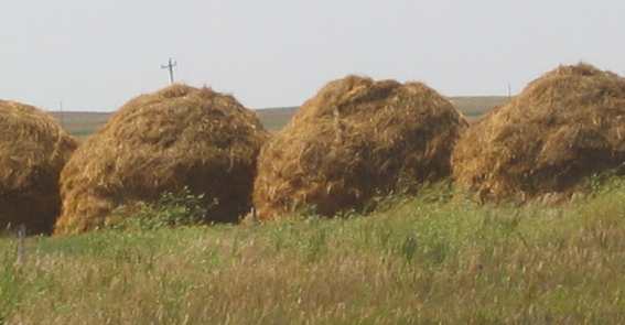
Hay piles in Nebraska
This hay resembled bells so we called them "bell-hay".
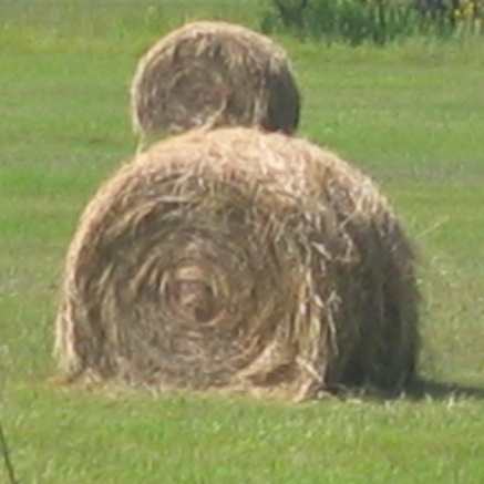
Nebraska also has rolled bales of hay as well
This is roll hay and is the most popular method.
Each landowner has a different way to deal with hay. There are large round bales, large rectangular bales, small rectangular bales, huge bell shaped piles then there are piles that look like huge loaves of bread. The most common seems to be the large round bales.
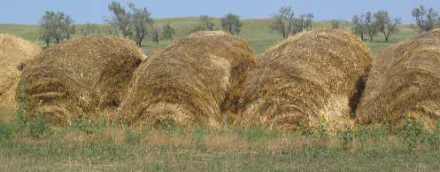
Another variety of Nebraska hay storage
And finally these are what we call "loaf-hay". A vicious cross wind out of the southeast buffeted the side of our motorhome as we traveled. Any of you that are traveling in motorhomes know that a side wind makes steering more complicated. It wasn't that big a deal since Nebraska State Road 12 doesn't have much traffic on it. In the past two days we have found ourselves amid diverse Nebraska landscapes that ranged from wetlands to croplands to prairies. Wildflowers are abundant the entire length of State Road 12 as are forested bluffs near the rivers, several winding rivers (Missouri & Niobrara Rivers), sandhills, grasslands, waterfalls, lakes and high prairies. State Road 12 also has abundant historical reminders such as museums, military forts, and refurbished buildings all reminiscent of rowdier times.
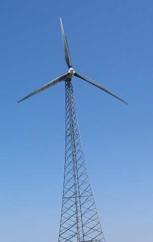
Wind Generator near Springview, Nebraska
In the small town of Springview we stopped to watch and read about what may become the newest pay crop in this area. That would be the two experimental wind turbines located a mile west of town. At 750 kilowatts each they are billed as "America's largest wind turbines". The overall height of these monsters from ground to blade tip is 296 feet. The towers are 207 feet. The variable speed blades rotate at 16 to 30 rpm. Blades are made of reinforced fiberglass with each blade being 79 feet in length. The "rotor" diameter is 164 feet. One day we may pass by here and see wind generator farms. By the time we reach Valentine we are beginning to see yucca. That tells us the landscape is getting dryer.
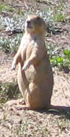
Nebraska prairie dog
After getting the motorhome settled in Valentine we jumped in the Saturn to visit Ft Niobrara where all the buffalo and elk were, or so we thought. Advertisement, met reality without much fanfare. The National Wildlife Refuge is located 4-miles east of Valentine so it wasn't a long drive. Prairie dogs should be on the cover of all Fort Niobrara literature and advertising. Those little barking dogs or barking squirrels are everywhere. We didn't see any buffalo, but we did see a small group of elk. Before they were killed off elk were numerous in Nebraska. Settlers had killed the last Nebraska elk by the early 1880's. Elk are now being raised on large ranches and places like this Wildlife Refuge. The Nebraska turkey suffered a similar fate. However, turkey like elk, have been reintroduced and are thriving. Today in some areas like the small town of Spencer wild turkeys are abundant due to the efforts of local citizens. In 1960 a group of area farmers, businessmen and residents purchased wild turkeys to be released in the area. Thirty-two people contributed funds to purchase 85 turkeys at $5 each from South Dakota. The businessmen used a borrowed chicken hauler to transport the purchased turkeys. Note that the Nebraska Game & Parks Commission was not involved. This was all a local effort. The result is a tremendous wild turkey population around Spencer.
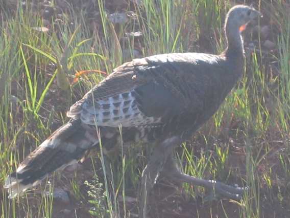
Wild turkey in Nebraska
Turkeys are obviously thriving in northern Nebraska. We saw that large group this morning then we saw a number of them in Ft Niobrara Wildlife Refuge then again near the city limits of Valentine we watched a turkey hen with a brood of chicken size chicks cross the road in front of us then linger in the short grass along the road.
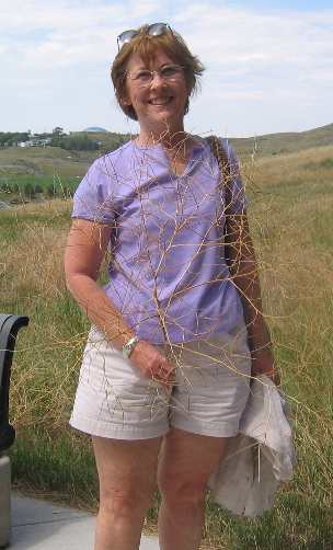
Sunday August, 22; Valentine Motel & RV-Park. Valentine, Nebraska: N42° 51.993': W100° 32.750' $22.50 gravel pad & interior roads full hookup 30/50-amps with cable TV & phone connection @ each site no extra charge. Fatigue set in. We declared this a down day where we slept late, washed the motorhome and cleaned it inside. I took advantage of the onsite modem connection to upload travelogues to my web site and send travelogues to the distribution list. Tomorrow our plan is to head to Pierre South Dakota approximately 135-miles north of here. Monday August, 23: Griffin City Park - Pierre, SD: N44° 21.481': W100° 20.602' $10.00 gravel pad paved interior roads 30/50-amps central water & dump. The drive from Valentine, Nebraska to Pierre, South Dakota was uneventful. The surrounding landscape was changing with each passing mile. With every mile we go north or west there is more range land and less cultivated fields. Corn and soybeans have been left behind. Rolling hills and short prairie grass range land makes up 95% of the landscape. We spotted yucca for the first time on this trip as we entered Valentine, Nebraska the other day and saw some more today on our way to Pierre. Yucca is a sure harbinger of a dryer harsher climate. We were traveling US-83 north. North of I-90 on US-83 we started seeing cultivated fields of sunflowers as far as the eye could see. Then as we approached Pierre we started seeing cultivated fields of sorghum. We didn't spot any irrigation in these fields. Sorghum and sunflowers must not require irrigation. The sunflower and sorghum fields were the first we have seen on this trip also. We were on the lookout for antelope but did not see any. We did see a herd of about 30-wild horses south of I-90. I say wild because there wasn't a fence to be seen and we could see across an area the size of Delaware. The livestock industry is the largest component of agriculture in South Dakota. Farmers and ranchers work hard to keep their livestock safe and healthy. In summer their big challenge is providing safe clean water. In the winter ranchers must provide their animals hay and mixed grains because much of the grass is covered by snow. Over half of South Dakota is grassland. Much of this land is not suitable for crops to grow. Ranchers let their cattle graze on these grasslands. Grazing is an efficient way to use this land. Ranchers move cattle from one pasture to another to let the grass grow back thus keeping the cattle and pastures healthy. Cattle and grasslands have a symbiotic relationship in that cattle utilize the grass for food and nutrition while planting grass seeds by pressing seeds into the soil where it can grow. Manure is a natural fertilizer and seed spreader for prairie plants and grasses. We were traveling north on US-83 not far into South Dakota when we passed through the Rosebud Indian Reservation. A marker on the side of the road told the story of how the movie "Rosebud" had been filmed here. From the marker they described different scenes in the movie and pointed to where that portion had been filmed. We were not familiar with the movie "Rosebud", perhaps you are. We also saw our first ring neck pheasant, the South Dakota state bird today. I spotted him on the side of the road in some grass. I turned the car around so Joyce could get a good look. As I approached in the car he disappeared in a patch of taller grass so I got out of the car and played like a bird dog flushing him so that Joyce could get a look. Joyce with South Dakota tumbleweed
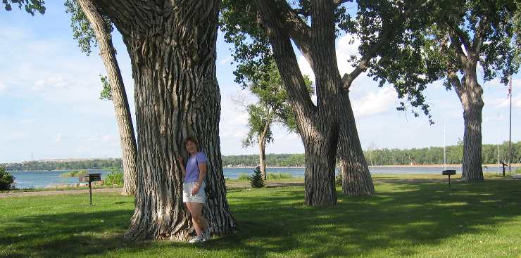
We also spotted the first tumble weed of this trip. We also saw several white pelicans in a large pond as we traveled on US-83 south of I-90. I was surprised to see these white pelicans but there was no mistaking them. Once in Pierre we had our choice of campgrounds. We could either stay in Pierre at their Griffin City Park located downtown on the Missouri River for $10 a night or across the river in Lilly City Park (city of Ft. Pierre) on the west bank of the Missouri River for $10. Both parks are nice and both are within 2 or 3 miles of the major things to do in and around Pierre. Griffin City Park in Pierre is about 8-blocks from the South Dakota State Capitol building. Joyce had a big day planned for us in Pierre so we didn't waste much time before heading out to see what Pierre had to offer. Things clicked like clockwork and we were able to visit many of the places Joyce had planned. Pierre, South Dakota is one of those places where a lot of history has taken place but before we get into that you need to know a little about Pierre as it is today. The Missouri River flows north through South Dakota. Pierre is situated on the eastern bank of the Missouri almost in the center of the state. The town boasts a population of 13,200. That may sound small but locals are quick to point out that they are not the smallest Capitol City, according to them Montpelier, Vermont is smaller. Across from Pierre is the community of Ft. Pierre. Several significant things happened in this community. Back in 1743 two Frenchmen, the Verendrye brothers, who were trying to find the famed "Northwest Passage" buried an engraved lead plate claiming this land for the King of France. The lead plate was found in 1913 by some local high school boys and is evidence of the earliest known visit of white men to this area. The view from this promontory above the town of Ft. Pierre overlooking the Missouri River valley is simply awesome. Some literature would lead one to believe that Lewis & Clark were the first white men to explore this far west. That just isn't the case. These two Frenchmen were here 61 years before the Lewis & Clark expedition passed by and had their near fatal encounter with the Teton Lakota at the base of this promontory. In September of 1804 when Lewis and Clark passed this way they had a Council Meeting with the Chiefs and several hundred members of the Teton Lakota (Teton Sioux). The Council was held on a sandbar at the mouth of the Bad River. After both sides had exchanged and eaten food, negotiations began. It was evident that the Teton Lakota wanted to extract a LARGE tribute of gifts and goods from the expedition as the price for allowing them to proceed upriver. In an attempt to divert them from their demands the Captains Lewis & Clark took the chiefs on board the Keelboat and entertained them there. It was only with difficulty that Clark managed to get them into the pirogues to take them back to land. When they reached the bank, three warriors seized the end of the rope, while another locked his arms around the mast and they told Clark the expedition could go no further. Clark drew his sword, Lewis ordered the swivel guns on the keelboat made ready, and the rest of the party cocked their rifles. In response the Indians fitted arrows to their bows and raised their muskets. The council nearly ended in disaster. Joyce next to this huge Cottonwoon tree in Lilly Park in Ft Pierre, South Dakota along the Missouri River
This is the spot at the mouth of the Bad River where L&C had their bad experience with the Sioux. Those are cottonwood trees that Joyce is standing next to. The Teton Sioux were the "900-pound Gorilla" of this region. The Teton Sioux were notorious for stopping upriver trading parties forcing them to dispose of their goods at ruinously low prices. This amounted to little more than robbery. Occasionally, however, after extracting exorbitant tribute, they had permitted parties to go on upriver. Lewis and Clark knew about these tactics of the Sioux and were very much concerned. They also knew that assertion of American authority and sovereignty was absolutely essential to both the domestic and foreign policy of the United States. Earlier they had met one of these victims Regis Loisel, whom the expedition met coming down the river three days out from St. Charles, on May 24. Loisel had suffered extreme humiliation from the same Indians whom the expedition now met. The Sioux not only extracted tremendous tribute from traders heading upriver they terrorized, robbed and plundered other Indian tribes in the area. These same Indians had stolen Private John Colter's horse from him while he was hunting two days earlier. So that is the setting. The expedition heavily outnumbered, could have ended right here. Fortunately, Chief Black Buffalo diffused the situation and in fact, over the next two days, hosted the men of the expedition as guests at his village, a few miles upstream. The Corps of Discovery proceeded on. The flag of the United States is said to have first flown over present-day South Dakota at this historic meeting. The spot where all this occurred has been preserved at Lilly Park in Ft Pierre. The park is on the Southwest bank of the confluence of the Bad River and Missouri River. A well manicured city park with stately old Cottonwoods and a series of kiosks now mark this historic site. Lilly Park also has about 20 places for RVs with water and electricity and central dump site for $10 a night right on the Missouri River. Pierre promotes self guided State Capitol tours in their tourist information so we dropped by to take one. The impressive structure was built in 1910. Its elaborate interior features Greek and Roman design. Marble wainscoting and columns, terrazzo tile floor, Victorian leaded glass and brass door fixtures create a grand and distinguished look. The Capitol was constructed with a variety of materials including native field stone, Indiana limestone, and Vermont and Italian marble. It features hundreds of hand-crafted materials including carved woodwork and marble, special cast brass, and hand laid stone. The floor in the Capitol is inlaid Italian terrazzo tile. Each terrazzo tile was individually hand laid by 66 Italian artisans. As you know artists often leave their signature on their individual piece of art; however, in this case it was impossible for each Italian artist to leave a personal signature of his craft in the stone flooring of the Capitol. Instead, each artist was given a special blue stone as a "signature stone" for the artist to place somewhere in the Capitol at the artist's discretion. Only 55 of the 66 blue stones have ever been found. We found 3 but did not look that hard. Immediately upon entering the Capitol you find yourself in front of a grand staircase and directly under the Capitol Rotunda "under the dome". The ceiling of the Rotunda dome is 96' and features Victorian leaded stained glass. We spent time examining the Senate and House of Representatives rooms then checked out the South Dakota Supreme Court. Of course the House and Senate were not in session and the Supreme Court was not sitting. A few miles north of Pierre is the Oahe Dam and Lake Oahe. This major dam on the Missouri River was completed in 1962 and was the largest rolled-earth dam in the world at the time. The Aswan Dam in Egypt constructed a few years later is a bit larger. This really is a BIG dam in terms of size. It is 245 feet high, 9,300 feet long (nearly 2-miles) and the width at the base is 3,500 feet (2/3 of a mile). The reservoir or lake created by this dam stretches 231 miles north to Bismarck, North Dakota. The lake covers 347,000 acres of land and has 2,250 miles of shoreline (more than the coast of California or for that matter the entire west coast of the United States from Bahia to Puget Sound. Oahe Dam will shortly become the 3rd largest rolled-earth dam in the world when the behemoth being constructed in China is completed. The lake appeared to us to be down over 50 feet. A local said that a number of years of light snowfall in the Rockies had caused this condition. We didn't take the powerhouse tour but they have one. Joyce isn't into powerhouse and electricity generating tours and I am not going to push my luck. On the way to view Oahe Dam we stopped by Fort Pierre Chouteau. Between 1832 and 1855 Fort Pierre Chouteau was the largest trading fort on the Upper Missouri. The fort was the headquarters for the American Fur Company's UMO Upper Missouri Outfit which covered the present day states of North Dakota, South Dakota, Montana and northern Wyoming. Sioux Indians brought about 17,000 buffalo robes a year and other furs here to trade for guns, tobacco, blankets, kettles beads and other supplies. Indian bands were greeted with Canon Salute, followed by a welcome ceremony and feast. At times hundreds of tepees covered the plains around the fort. Steamboats delivered trade goods to the fort and returned loaded with robes bound for New York. In the 1840s robes were brought overland from Fort Laramie in present day Wyoming to Fort Pierre for shipment down the Missouri. In 1855 the fur company sold the Fort to the U.S. Army, which used it one year before moving downstream to Fort Randall. If you have not guessed by now the communities of Pierre and Ft Pierre were named for Pierre Chouteau the man who built & operated Fort Pierre Chouteau. Pierre is the "center" of things. It is midway between
the mouth of the Missouri River at St.
Louis, Missouri and the source of the Missouri River in western
Montana. It was the center of
the Fur Trade for half a century. It is said that there is a marker
south of town that marks the center of the state of South
Dakota. Eight different trading posts and two different forts
were within a days walk. It was here in 1831 that the steamboat Yellowstone
arrived to carry away buffalo hides and eventually decimated the once
fabulous herds. Army expeditions in 1863 and 1864 against the Sioux
began from here. And finally it was here in 1876 that steamboats dropped
off equipment and men destined for the gold rush in the Black
Hills just west of here. To any historian this is "Historic
Ground". Click here for more South Dakota travellogsUntil next time remember how good life is. More Nebraska AdventuresAdventures by State ** 2004 Travel Adventures
Mike & Joyce Hendrix
Mike & Joyce Hendrix who we are We hope you liked this page. If you do you might be interested in some of our other Travel Adventures: Mike & Joyce Hendrix's home page Travel Adventures by Year ** Travel Adventures by State ** Plants ** Marine-Boats ** Geology ** Exciting Drives ** Cute Signs ** RV Subjects ** Miscellaneous Subjects
We would love to hear from you......just put "info" in the place of "FAKE" in this address: FAKE@travellogs.us Until next time remember how good life is.
|
| ||
|
| |||
|
| |||
|
|