Geology of Sandia Peak Albuquerque, New MexicoMay 11, 2007. We are staying at Hidden Valley Resort, a PPA park $11.88 FHU 30-amps nice level pull-thru sites with gravel interior roads and sites. Level sites in New Mexico are a bonus. VBG For those of you that are not familiar with PPA (Pass Port America) it is an organization you can join for less than $50 per-year. Campgrounds that belong to PPA offer 1/2 price discounts. That kind of savings can quickly add up. While participating PPA parks generally have some restrictions on dates the PPA offer is valid, or possibly days of the week the discount is valid, or perhaps the number of days that the PPA discount will be honored the discount is genuine. Many times PPA campgrounds are new campgrounds that need help in getting established. Other times PPA campgrounds may be on the outskirts of town instead of in the "prime" location thus they need to provide an incentive for campers to stay with them. Whatever the reason PPA campgrounds generally provide a much cheaper option. PPA is the only campground organization that I think is worth the cost. PPA does not have a gimic. What you see is what you get. Once you join they send you a directory listing all participating campgrounds. The PPA directory is the FIRST directory we check when trying to locate a place to spend the night. You can join PPA by calling 228-452-9972. If you decide to join PPA, it would be nice if you gave them my number "R-0156251" as the PPA member that told you about PPA. In return PPA will give me a years membership free. I will thank you in advance for that kindness. Thank you.
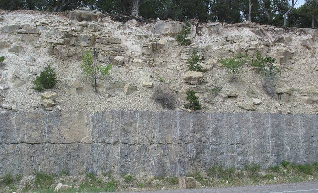
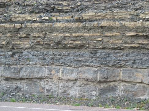
Volcanic ash in sedimentary road cut
As we head north on SR-14 we are treated to a wondrous variety of roadcuts. The layer of sedimentary rock on the bottom is obviously very hard while the sediments on top are much softer. The soft layers look to me like they contain a lot of volcanic ash.
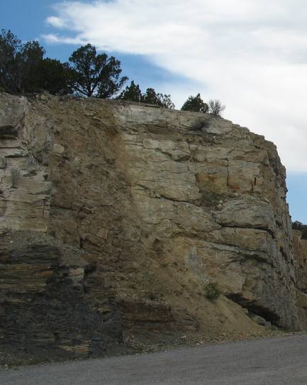
Geologic fault
What happened here? Something happened vertically in this sedimentary layer of rocks. This is an ancient fault. I can tell this because the sedimentary layers of rock on both sides of this vertical event don't line up like normal layers of sedimentary rock. The more I look at it the more it looks like the right side has moved up while the left side appears to have moved down. Whatever, the event occurred so long ago that debris has filled in the resulting cracks and obscured a clear view of the movement. In any event this is an awesome examle of a geologic fault.
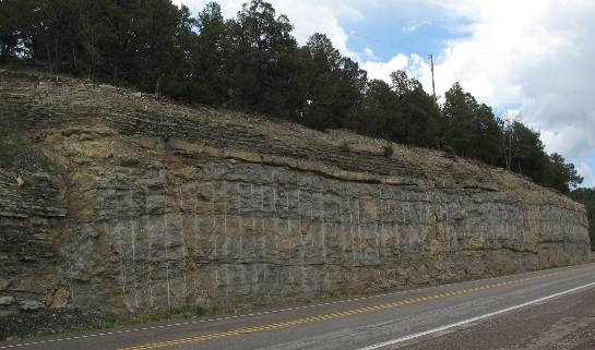
Geologic fault
This is road cut of sedimentary rock with another one of those vertical events clearly seen on the extreme left side of this picture. Here it looks like the left side dropped while the right side rose. I think I can make out where the two levels of sedimentary rock once connected before the faulting. When the earth shifts either up, down or sideways and fault or crack is created that is over time filled with debris. This "debris field" is clearly visible as it intersects the horizontal layers of sedimentary rock.
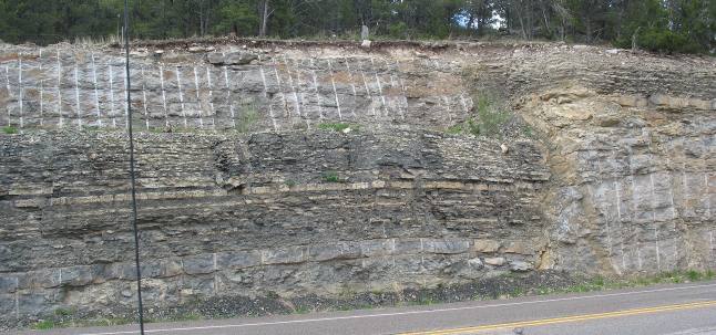
Geologic fault
This an ancient fault line? You can clearly see the thin bedded shale on the top layer of the right side of the fault. It appears to me that the layer of thin bedded shale is about 5-feel lower on the left side of the fault. Again this event must have taken place long, long ago. When I see visual evidence like this it helps me visualize how these mountains were formed.
Layers of sedimentary rock in road cut
This is an interesting road cut exposing multiple layers of sediments that must have developed in a wide variety of climates over millions of years.
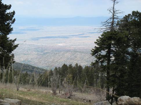
View from road up to Sandia Peak
Somewhere on the way up to Sandia Peak we got this glimpse of the wonderful plain stretching to the north. I think those low hills you see in the distance are the Cerrillos hills where we were the other day when we visited friends in Cerrillos.
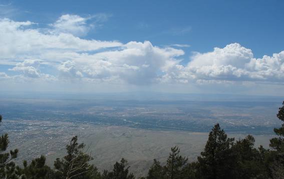
On Sandia Mountain we are nearly two miles above sea level (10,678') and one mile above the city of Albuquerque. They say you can see 100 miles in all directions on a clear day. This isn't a clear day. The rosy colored granite of the face of the cliff visible from Albuquerque turns crimson when the setting sun reflects on it. Early Spanish settlers named the mountain for that watermelon color. Sandia is Spanish for watermelon. The tram that rises from the western valley to another spot on Sandia Peak almost 2-miles south of where we are. We wrote about that tram ride in another travelogue several years ago. This time we have a digital camera with us.
Rio Grande Valley and Mt Taylor as seen from Sandia Peak
This view looking west across the Rio Grande Valley features the Rio Grande River flowing through the center while 11,300' Mt. Taylor, one of New Mexico's highest peaks, is in the distance------remember that Mt. Taylor is 60-miles west of us.
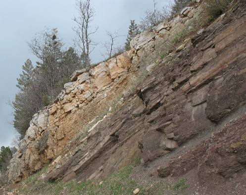
Evidence of uplift
The Sandia mountains were created by an uplift, leaving a forested eastern slope and a craggy, cliff-like western face. This roadcut has exposed the uplifted sedimentary rocks tilted at about 45-degrees. The Sandia Mountains are a fault block range, on the eastern edge of the Rio Grande Rift Valley. Rifts are created when sections of earth are pulled apart by tectonic forces. The Rio Grande valley literally fell (over time) as both sides of this rift uplifted leaving the section in the middle to slide down and that is exactly what the Rio Grande Rift Valley has done. The Sandias were uplifted in the last 10 million years. The picture to the left clearly shows the uplift that has occurred tilting this sedimentary rock at an almost 35-degree angle. The Sandia Peak cliff face seen from Albuquerque is an east-tilted fault block 1.4 billion-years in the making. Precambrian granite (the earliest era of geological history or more than 2.5 billion years ago) topped with 300-million-year-old Pennsylvanian sedimentary rocks. The height of these mountains is emphasized by how far below the Rio Grande Valley (also known as the Rio Grande Rift) corresponding layers of rock occur. The same Pennsylvanian sedimentary rocks are nearly 20,000 feet below the valley floor. If you add this 20,000 feet to the height of the mountains above Albuquerque the total fault movement is 26,000-feet or about 5-miles of movement. The vast majority of this awesome rift is hidden beneath almost a mile of rubble bordering the west side of the mountain range. Albuquerque is located on that huge pile of rubble. This block fault Geology resembles the fault block mountains of the Teton Range. The difference with this block fault, in my eyes, is the location of the fault. This is an east-tilted block fault meaning the bottom of the rift is on the western side of the uplifted block while in the Tetons the uplifted block is west-tilted with the rift valley on the east side of the uplifted block.
More New Mexico AdventuresSome Exciting Drives** More 2007 Travel Adventures
Mike & Joyce Hendrix
Mike & Joyce Hendrix who we are We hope you liked this page. If you do you might be interested in some of our other Travel Adventures: Mike & Joyce Hendrix's home page Travel Adventures by Year ** Travel Adventures by State ** Plants ** Marine-Boats ** Geology ** Exciting Drives ** Cute Signs ** RV Subjects ** Miscellaneous Subjects
We would love to hear from you......just put "info" in the place of "FAKE" in this address: FAKE@travellogs.us Until next time remember how good life is.
|
| ||

| |||
|
|
|||
|
| |||
|
|