Idaho's Weippe PrairieIdaho's Weippe Prairie
June 27, 2007 We are staying at: Hells Canyon Resort in Clarkston, Washington. Hells Canyon Resort is a top notch RV-Resort at $30 per-night with cable and wifi; FHU totally paved interior roads and pads.
We are heading east on US 12 along the Clearwater River to the small town of Greer where we are going to turn onto SR 11 and head out to Weippe another small community with tremendous history.
Where Lewis & Clark returned to traveling in canoe's to complete their westward journey
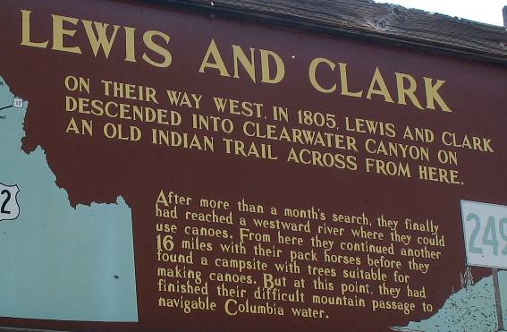
Along the Clearwater River near Greer we stopped at this kiosk maintained by the State of Montana.
For those who have read about Lewis and Clarks Corps of Discovery you will recall how important this area was on their transcontinental journey.
The mission of the Corps of Discovery was to locate a water route across the continent. After traveling to the headwaters of the Missouri River, then crossing the Bitterroot Mountains on foot this is where the Corps of Discovery again took to the water to complete their journey to the Pacific Ocean.
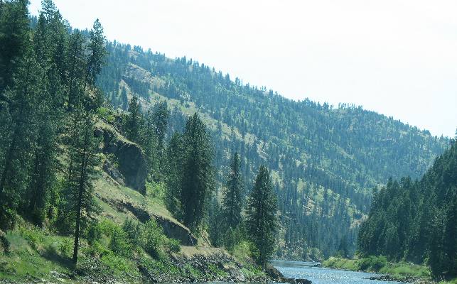
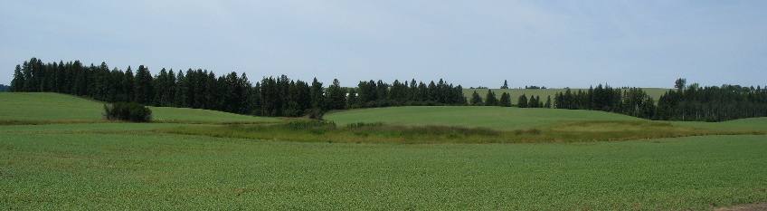
Hill leading from Weippe Prairie to Clearwater River used by Lewis & Clark
This is the hill Lewis & Clark came down. The Weippe Prairie is on the plateau at the top of this steep grade. Lewis and Clark have come from the Weippe Prairie down this grade where they constructed canoes and continued their journey to the Pacific Ocean.
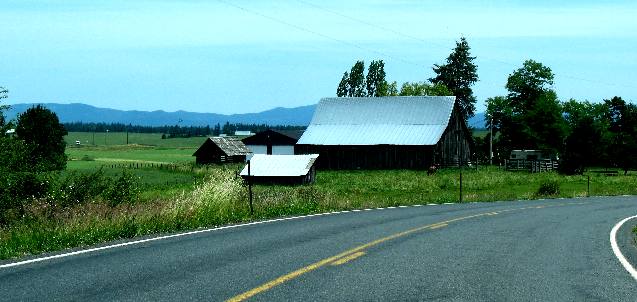
We continued our journey along the Clearwater River until we got to the small community of Greer. At that point we turned east on SR 11 and headed to Weippe the historic place on Lewis and Clarks epic journey where they met a band of Indians that fed them when they were starving.
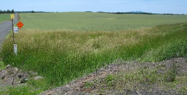
Once we climb up the canyon wall to theWeippe Prairie Plateau we are greeted with breathtaking scenery, complete with numerous hills, mountains, forests and valleys to delight any photographer. There are plenty of historic sites to experience, including the site where the starving Lewis and Clark Corps of Discovery met the Nez Perce Indians on the Weippe Prairie after crossing the terrible Bitterroot Mountains.
Weippe Prairie
Weippe, nestled on the eastern edge of the Weippe prairie, has an interesting and historical background dating back to before the coming of the white man. Here on the high mountain prairie the Nez Perce Indians came to dig the camas bulb, so important to their daily diet.
Weippe Prairie
It was also here in September, 1805, that Meriwether Lewis and William Clark and their “Corps of Discovery” encountered the Nez Perce for the first time. A stone monument commemorating this event has been placed along the highway entrance to Weippe and on the Opresik farm where the actual meeting took place. The Weippe Prairie is one of eight registered national landmarks in the State of Idaho. The Weippe prairie is still a beautiful and charming upland. Farm buildings and fences are in evidence but enough open area still exists to suggest the unspoiled prairie seen by Lewis and Clark.
Much study has been done concerning the name Weippe (Wee-yipe). The word was originally spelled Oy-ipe by General Howard in his journals. A late Nez Perce historian said the name meant “very old place.” The Nez Perce also say it may have something to do with a spring of water or camas ground.
Weippe Prairie
When Lewis and Clark came to the Weippe Prairie they were near starvation and the Nez Perce Indians welcomed them with salmon and bread made from the camas root. The Weippe Prairie and Musselshell Meadows were considered beds for the finest camas. The bulb, properly baked and dried will keep for many years without spoiling. When baked the camas is ground up for bread and porridge.
The journey along Idaho's Highway 11, Idaho's Gold Rush Historic Byway, has taken us from the crossing of the Clearwater River at Highway 12 in Greer, through the rolling wheat fields and camas prairies to Weippe. This is the story of Lewis and Clarks epic journey from their point of view: Stumbling down from the Bitterroots, the Corps of Discovery reached the western terminus of Lolo Trail by late September 1805 and ventured out onto Weippe Prairie. Clark and seven of the men had pressed ahead arriving September 20th, shortly ahead of the rest of the group that made it to the prairie by the 22nd. Spanning several thousand acres, the open flatland was a welcome sight after the crew's brutal trek through the Rockies. Even more welcome were the friendly faces of the local Indian nation, the Nez Perce. On September 20 Clark wrote: ". . . Proceeded on through a beautiful country for three miles to a small plain in which I found main Indian lodges. Those people gave us a small piece of buffalow meat, some dried salmon berries & roots . . . They also gave us the bread made of this root, all of which we eate hartily . . . They call themselves Cho pun-nish or Pierced noses. I find myself very unwell all the evening from eateing the fish & roots too freely . . ." Establishing contact with this group for the first time, Lewis and Clark communicated via sign language with one of the Nez Perce leaders, Chief Twisted Hair. Over the following two and a half weeks, the Corps stayed with the Nez Perce, specifically within their two villages located at the southern end of Weippe Prairie. There, the Americans rested, recuperated, and learned much from the Nez Perce, namely the existence of a navigable water route to the West Coast. Furthermore, they learned why the Nez Perce chose to reside in the shadow of the Bitterroots. Unbeknownst to the pioneers, Weippe Prairie, also known as the "Quawmash flats," was an area rich in the camas plant/root, providing the Nez Perce with a consistent and healthy food source. Aside from giving the expedition their fill of camas, the Nez Perce provided for the pioneers in other ways. Twisted Hair accompanied the Corps to a canoe camp, where the expedition members immediately set to constructing canoes in preparation for their journey down Clearwater River and beyond. The explorers were finally ready to set out for the Pacific by mid-October 1805, by way of the Columbia River. On their return journey in the spring of 1806, the Corps again stayed with the hospitable Nez Perce of the Weippe Prairie Waiting until the snow melted and Lolo Trail again became passable, the pioneers resided on the "Quawmash flats" for over a month. There they built a temporary structure, of which there are no present-day remains. The crew developed considerable respect for the Nez Perce during their stay, both for the genteel nature of the Indians and the quality of their horses, the Nez Perce-bred Appaloosa. Weippe Prairie, a National Historic Landmark administered by the National Park Service, is part of the Nez Perce National Historical Park. There are two main Visitor Centers, one at Park Headquarters in Spalding, Idaho, 11 miles east of Lewiston and the other at Big Hole National Battlefield, 10 miles west of Wisdom, Montana. The Visitor Center at Spalding, Idaho is open in the winter months from 8:00 am to 4:30 pm and until 5:30 pm in the summer. The Visitor Center at Big Hole National Battlefield near Wisdom, Montana is open in the winter from 9:00 am to 5:00 pm and in the summer from 8:30 am to 6:00 pm. Call 208-843-2261, or visit the park's website for further information.
From Weippe we backtracked on SR 11 to Greer then on US 12 as we started heading back to the motorhome. But we just had to stop in Orofino for a visit to Dworshak Dam. Dworshak Dam is one of those engineering marvels that one has to visit when in the area. Dworshak Dam is a 717 foot high concrete structure that happens to be the highest straight axis gravity dam in North America. The dam backs up water from the North Fork of the Clearwater River forming a 54-mile lake at "full pool". Flood control, power production, and recreation are the benefits of the Dworshak Project.
Click here for more Idaho travellogsUntil next time remember how good life is.
More Idaho AdventuresSome of our Miscellaneous Subjects ** More 2007 Travel Adventures
Mike & Joyce Hendrix
Mike & Joyce Hendrix who we are We hope you liked this page. If you do you might be interested in some of our other Travel Adventures: Mike & Joyce Hendrix's home page Travel Adventures by Year ** Travel Adventures by State ** Plants ** Marine-Boats ** Geology ** Exciting Drives ** Cute Signs ** RV Subjects ** Miscellaneous Subjects
We would love to hear from you......just put "info" in the place of "FAKE" in this address: FAKE@travellogs.us Until next time remember how good life is.
|
|
||

|
|||
|
|
|||
|
|
|||
|
|