Places Visited: Wyoming: The scenic Teton National Park July 30 through August 5, 2006: Colter Bay Village Campground in Teton National Park near Moran, Wyoming: N43° 54.659' W110° 38.526' $15.00 NO hookups with paved interior roads and gravel spots. Nice, clean park and you really do not need hookups in the summer. August 5, through August 12, Gros Ventre Campground in Teton National Park near Jackson, Wyoming: N43° 36.979' W110° 40.000' $15.00 NO hookups with paved interior roads and gravel spots. Nice, clean park and you really do not need hookups in the summer. We moved the motorhome from Jackson Hole to Colter Bay Village in the northern part of Teton National Park. That entire drive was through Teton National Park Valey, with the mighty Tetons providing a backdrop on our western flank. A more scenic drive is hard to find. Eight days later we retraced our path and moved the motorhome south to Gros Ventre Campground just north of Jackson where we spent another week.
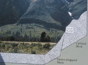
Geologist look at the Tetons and marvel at the structure. With trained eyes they see thing most of us would not notice. One of those things is a prominent "fault scarp". A fault scarp provides visual evidence of displacement of adjoining blocks of the earth's crust along a fault. The "scarp" in this picture shows nearly 60-feet of movement, mostly in the down-dropping of the valley. This movement generated earthquakes of the highest magnitude. Geologists estimate that displacement will continue as it has for the last nine million years. Through periodic earthquake producing jolts, the mountains will hinge upward and the valley will tilt downward.
The Teton Range, one of many minor ranges associated with the Rocky Mountains, is in its early stages of development. Though associated with the Rockies, the Tetons are much younger and have formed in a different way. During the past 5 to 9 million years, cataclysmic earthquakes rumbled along the Teton Fault, a break in the Earth's crust. West of the fault mountains rose, while east of the fault a valley, now known as Jackson Hole, sank. The Teton Range, with its absence of foothills and exceptionally steep hillsides on its east side, is a classic example of a fault block mountain range.
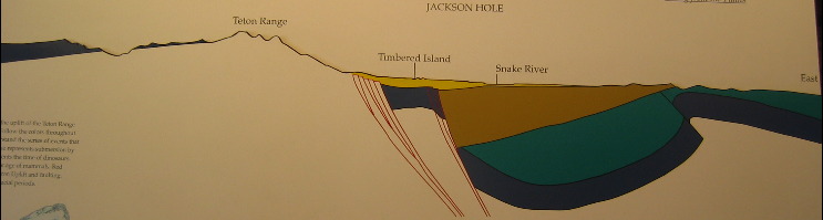
This cross section shows the uplift of the Teton Range relative to Jackson Hole. Follow the color throughout the exhibit to better understand the series of events that created this landscape. Blue represents submersion by tropical seas. Green represents the time of dinosaurs. Gold represents the present age of mammals. Red represents the period of Teton Uplift and faulting. Yellow represents recent glacial periods.
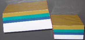
This model represents the vertical movement along the Teton Fault, 5 to 9 million years ago. The block to the left represents the Teton Range while the block to the right represents the valley called Jackson Hole. The colored layers represent rock layers in their present positions relative to each other across the fault. The movement along the fault resulted in the valley sinking four times faster than the mountains rose.
This model represents the role of glaciers and other weathering processes in sculpting the mountains since their uplift. The material eroded from mountian valleys, carried by streams and glaciers and deposited in Jackson Hole has filled the valley with aboyt 24,000 feet of rocks, sand and clay. As Fritiof Fryxell, noted geologist and first Park Ranger explained "The Teton peaks wer not individually upthrust. They attained their eminence and form through being carved from a common mass...just as, under the hand of a sculptor, figures are chisled from a block of stone. In fact, the Teton Range is rightly though of in this way, as a piece of sculpturing, collossal in scale and superb in composition." For every foot the mountains rose, the valley sank about 4-feet. so it wasn't so much a process of mountain building as it was of valley forming. The sandstone layer that cas Mount Morain, six thousand feet above the valley, corresponds to a layer of sandstone lying 24,000 feet below Jackson Hole. The total displacement along the teton Fault is currently 30,000 feet. The mountains do not tower above the valley by this distance today because the mountains have eroded and the valley has been partially filled with glacial debris and river gravel. The geologic processes that resulted in mountain building and sculpting have aslo determined where plants grow, animals live, and people play. Where torrents of glacial outwash rivers swept across Jackson Hole, gravel terraces are covered with sagebrush that survives on dry, rocky soil. Where rich, water retentive soils have collected in the moraines of those same glaciers, coniferous forest thrive. Each habitat supports its own collection of wildlife. The assemblage of those habitats within the context of the Teton Range affords an unrivaled visual, intellectual, spiritual and physical experience. Mountain streams cascade melted snow towards the valley where it is collected by the Snake River. The cottonwoods and spruces that grow along the Snake River provide ideal nesting sites for bald eagles. Side channels are sometimes dammed by beavers establishing small lakes and marshes. Moose wade through yellow pondlily and eat the lush growth in the wet swampy areas near the river. The swift clean water makes floating the river or fishing for cutthroat trout a rare treat in a spectacular setting. I am just beginning to understand what they call an "outwash plain". Rivers flowing away from ice age glaciers spread out to form broad outwash plains. Nutrients and organic matter are carried downstream leaving only gravel and sand. As the Snake river entrenches itself, these gravel plains are left high and dry as river terraces. Being well drained, only plants adapted to arid conditions survive. Arrowleaf balsamroot is one of the showest spring wildflowers. Elk emerge from the shade of the forest at dusk to feed. the sagebrush plains offer open views of the Teton Range and easy observation of herds of wildlife when driving in Teton National Park. Comprehending the glaciation that occurred in this region during the ice age helps put things into perspective. I say comprehending rather than understanding because of the immense scale of the glaciers that did this carving. During the "Bull Lake Glaciation" (about 140,000 years ago), huge volumes of ice moved into Jackson Hole from surrounding mountains, filling it with glacial ice over 2,500 feet thick in places. Slow down for a minute and try to comprehend a valley 40-miles long and 10-miles wide filled with glacial ice over 2,500 feet thick and you can understand why it is so hard to comprehend. Glaciers only form when the summer melt is less than the winter accumulation. It must have been so cold during the summer that very little of the winter snow melted. Folks it takes a lot of snow to accumulate 2,500 feet of ICE. But I degress, so back to the Bull Lake Glaciation that formed much of what we see in Teton National park. Though much of the evidence of this period has been destroyed by later glacial events, scattered remains indicate it was extensive. The streamlined shape of some of the bedrock buttes on the valley floor, like East and West Gros Ventre Buttes, were all sculpted by these glaciers. The melting ice also left behind a pavement of cobbles.
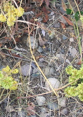
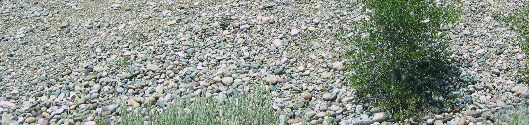
Cobblestones, river rock whatever you want to call it seems to make up the entire Teton Valley. No matter where you are there are these rounded cobblestones.
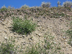
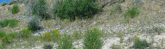
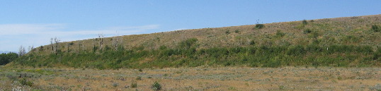
As you can see by this picture and the one below vegetation has a hard time surviving in what amounts to a pile of rocks. Some places in the morrain pile have more soil than others. Erosion, I suspect has played a major role in determining how much soil remains and how much is washed away.
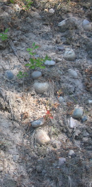
This picture was taken just a few feet from the one above yet there is almost no soil in this pile of cobbles to support plant life.
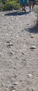
Even high on Signal Mountain we see these cobble stones in conglomerate near the summit. The glacier that created Jenny Lake and Signal Mountain was pushing this incredibly large wall of morrain. I suspect Signal Mountain is 800' to 1,000' above the floor of the valley. As far as I could tell Signal Mountain is nothing more than morrain. The picture to the left is from a roadcut near the summit while the picture to the left is a trail along the summit leading to an overlook. Both are composed of cobblestones from the leading edge of that glacier, making Signal Mountain one gigantic pile of morrain.
As the Teton Range was uplifted, erosion began to modify its appearance. Streams cut canyons, expanding ice and growing tree roots widen cracks, weathering takes its toll on unstable minerals and, pulled by gravity, rocks roll down steep slopes. glacial ice was a major agent of erosion over the last 2-million years. Glaciers pushed their way down once-narrow canyons grinding rock away to form broad U-shaped valleys. the hardest rocks remained as jagged peaks, chiseled on all sides. Erosion during the Ice Ages has had the greatest effect on the landscape of the Teton Range and Jackson Hole. When erosion finally outpaces uplift, the Teton peaks will become low hills and flatlands, but that will not be in our lifetimes. To understand how a glacier operates is to understand how the majestic Teton's were formed from a solid block. A glacier forms whenever more snow collects than is melted during the summer. After successive periods of snow accumulation, the snow is compressed into "blue ice" and begins to flow downhill under its own weight. Rocks are plucked from beneath the glacier and are carried along acting like sandpaper, gouging the valley bottom and sides into a characteristic U-shape.
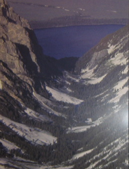
As glaciers leave the confines of stone-walled canyons and spread out, they dig deeply into the gravel filled valley. When the glacier melts, the rock debris is left in piles called terminal moraines creating deep lakes. You can see all those things in this picture of Cascade Canyon, the U-shaped canyon walls, the deep lake, and the huge pile of rocks (terminal moraine) on the far side of the lake.
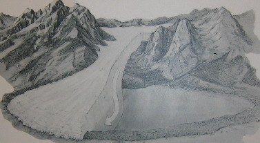
The glacier that shaped Cascade Canyon (pictured above) looked somewhat like this. When it left the confines of the mountains, the glacier gouged the gravel of the valley floor to a depth of 256-feet, piling up debris along its edge. The depression left by the retreating glacier is constantly being filled by streams to form the lake.
The front end of that giant wall of ice is pushing a huge pile of rock debris in front of it. When a glacier retreats it leaves behind this wall or pile of rock debris if you will. Morrains are evident throughout Teton National Park.
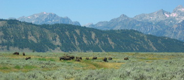
That is a huge pile of morrain behind those grazing buffalo in the picture to the left. Buffalo regularly traverse this pile of morrain along the Gros Ventre Road.
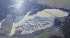
The large glaciers that once dominated this region have retreated to their last vestiges in the shadows of the high peaks. Although tiny compared to their ancestors, about a dozen small glaciers provide excellent examples of how glaciers sculpt mountain landscapes. All the parts of a glacier can be studied in compact Schoolroom Glacier shown here.
Jenny Lake was created by a glacier several thousand feet thick. Signal Mountain is the pile of morrain that glacier pushed in front of it before the earth started warming and the glacier retreated.
Joyce had her dancing shoes on while we were in Jackson and I can tell you, with certainty, that the Million Dollar Cowboy Bar in Jackson will never be the same. VBG Until next time remember how good life is. Mike & Joyce Hendrix
|
| ||

| |||