Places Visited: Wyoming: Fort Laramie, Guernsey and Casper (North Platte
River, US-26 and I-25)
July 7 & 8 2006: Casper East RV-Park Casper,
Wyoming. Casper East RV-Park is a mom and pop operation without a mom & pop!
N42° 51.357' W106° 17.338' $24 for water & 30-amps central sewage.
They feature gravel interior roads & pads: This is NOT a campground we would
relish staying in again however, it certainly looks much better than the Fort
Casper RV-Park.
We
got up this morning and headed west to Casper, Wyoming following the Oregon Trail.
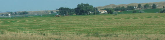
We were following the North Platte River on US-26. Lush fields of irrigated crops
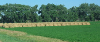
followed us into Wyoming. The picture on the right is a mowed field of alfalfa
hay where the hay has been raked into rows to dry. When the moisture content is
right the farmer will run a bailer through the field collecting the drying hay
and package it into bales like in the picture to the left.
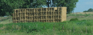
Hay
can also be baled into blocks like these.
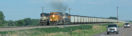
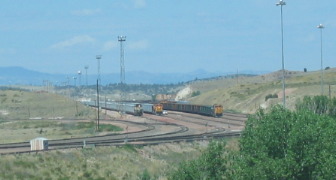
Coal trains run out of Wyoming
with a sticatto frequency heading from the immense coal fields to points east.
In one 20-mile stretch we counted five of these giant trains all carrying coal
east.
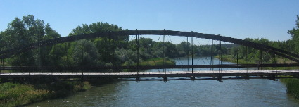
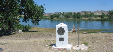
When
we arrived in Ft Laramie we turned south on SR 160. Within a few blocks we were
crossing the North Platte River and looking at an ancient bridge that crossed
the river a few yards down stream from the new bridge we were crossing. While
at Fort Laramie I read about the construction of this bridge and if I remember
correctly it was constructed during the Indian Wars period so that would put construction
in the 1870's or thereabouts. In any event it is an OLD bridge. The steel used
in construction was probably shipped in on the newly constructed railroad.
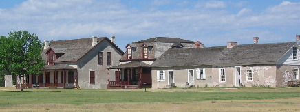
As
soon as we cross the river we can see old Ft Laramie National Historical Site
sitting prominently on a knoll overlooking the river. While visiting Ft Laramie
we learned that it was/is situated at the confluence of the North Platte River
and Laramie River even though we could not see water in either river from where
we were at the fort.
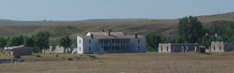
Fort Laramie was at the crossroads
of a Nation moving west. It may be the single most important location in America's
westward expansion. The fort had its origin in 1834 as a trading post. It did
not become a military fort until 1849 (the year 30,000 49'ers made their way west)
when the US Army purchased the fort. Fort Laramie remained an army post until
it closed in 1890.
Fort Laramie played a pivotal role in projecting
American will on the frontier. It was America's foothold in a rapidly changing
west.
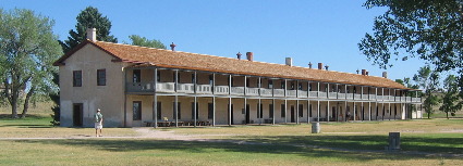
It served from the era of fur traders as fur company fort. Then as
a military fort it protected pioneers on the Overland Trail (Oregon Trail, Mormon
Trail, California trail-Pony express and stage coach lines) and saw the area through
the Indian Wars before closing.
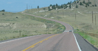
Some things are changing while others remain the same as we continue west
along US-26 in Wyoming.
The landscape reverts back to normal Wyoming sans
irrigation. However, the coal trains heading east remains constant.
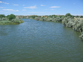
Another
thing that remains constant is the North Platte River we are following.
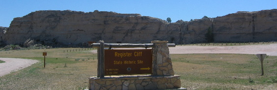
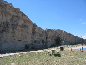
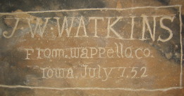
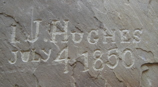
Our
next stop was in Guernsey, Wyoming at Register Cliff State Historic Site. Register
Cliff is a prominent cliff that runs along the southern flank of the North Platte
River. The relatively soft sandstone lent itself to "leaving your mark"
much as a dog does with a fire hydrant. The wayfarer's penchant for inscribing
names and dates on trees and cliffs gives us a view into their small window of
history.
Along this famed transcontinental route of the 1800's pertinent
dates from the 1820's through the 1860's can be found. Register Cliff invited
emigrants because of its broad river bottoms and lush pasture. Travelers eagerly
sought this rest stop where they could recoup during lay-overs. Here rest offered
the opportunity to "register" with name and date.
Emigrants
were not the only ones to "register". Early inscriptions were by Mountain
Men inured to wilderness life - many were descendants of two centuries of French
fur trade. One such inscription reads "1829 This July 14" He may have
been noting Bastille Day! Who knows?
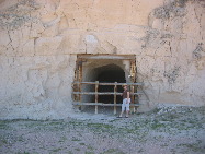
We
noted a cave in Register Cliff and wondered about it. Then we found a kiosk that
explained that one of the 20'th century property owners blasted this cave for
the storage of potatoes. The cool dark recesses of the cave offered ideal conditions.
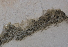
Cliff
swallows were also using the protection of Register Cliff as a home as can be
seen by this picture. This many cliff swallows in one colony can create an enormous
amount of activity. It was this activity that caught our attention.
For emigrants who reached this portion of the Oregon, California, Mormon Pioneer,
Pony Express trails between 1846 & 1868, the landscape was changing and new
challenges lay ahead. Rested and resupplied with provisions from Fort Laramie,
emigrants bound for destinations in Utah, California and Oregon now encountered
increasingly difficult travel conditions as they made their trek westward. It
would be 368 miles to the next major supply point Fort Bridger, or even further
if other cut-offs were taken.
The importance of the Oregon, Mormon
Pioneer, California and Pony Express Trail dwindled for emigrants with completion
of the transcontinental railroad in 1869. However, the trail was still utilized
by a few travelers and the military, especially after Fort Laramie became a hub
of activity during the Indian Wars period.
It is estimated that 500,000
people ventured westward over the trails to settle and develop the vast resources
of the American West. Soon, however these trails began to wain in importance.
With the completion of the transcontinental railroad in 1869 the 2,000 mile journey
that once took up to 6-months by wagon or on foot could be accomplished by rail
in a mere two weeks.
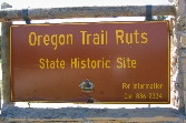
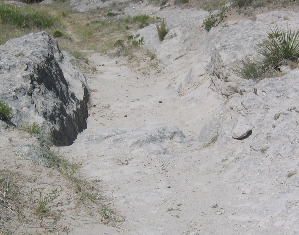
While
in Guernsey we also visited Origan Trail Ruts State Historic Site that preserved
visual evidence of the thousands of wagons that passed this way.
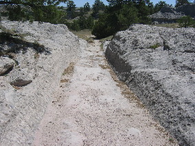
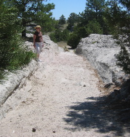
Through
a narrow passage at the crest of this hill, thousands of people and wagons cut
deep ruts into the sandstone.
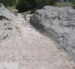
This
hill is just a days journey from Fort Laramie and less than 3-miles from Register
Cliff.
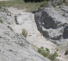
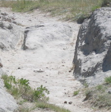
One
can only imagine how livestock and wagons struggled through this rocky terrain.
While the North Platte River provided critical water for livestock
and the emigrants themselves, it also provided a barrier to overland travel. The
river's waters were swift and treacherous especially in the spring and early summer.
That is why the trail went over this hill, to avoid the rushing waters of the
river just over the hill.
The road west can be described in a number
of ways: Settlement of new lands (Oregon & California), freedom from religious
persecution (Mormon migration to Utah), quest for personal riches (California
Gold Rush), communications (Pony Express) and commerce were all reasons for this
road west.
Although overlaps occur 5-general trail eras can be identified:
The Mountain Men discovered the trail and used it prior to the 1840's.
Then came the Oregon Trail era: The Bidwell-Bartleson wagon train left Independence
Missouri in the spring of 1841, bound for the fertile valleys of Oregon and Washington.
They pioneered the westward migration. Their 2,400 mile journey ended in Oregon
near the Columbia River Valley/Oregon City area.
Next came the California
Trail era: This trail started shortly after the first wagon train left for Oregon
but achieved prominence in 1848 when gold was discovered at Sutter's Mill in California.
In 1849 alone approximately 30,000 "Forty-Niners" used it to reach the
gold fields. Many more emigrants followed in subsequent years.
Then
came the Mormon Pioneer era: Seeking freedom to practice their religious beliefs,
Brigham Young led the followers of Mormonism from the banks of the Mississippi
River into what is today Utah. In 1846 they left Nauvoo, Illinois and wintered
along the Missouri near present day Omaha, Nebraska. In the spring of 1847 they
departed for the Great Salt Lake of Utah. By late July, the pioneers had completed
their 1,400 mile trek. Inspired by this first group of 148 emigrants, nearly 70,000
followed the trail over the next 20-years, most seeking sanctuary in the Great
Salt Lake Valley.
Finally the Pony Express days: With emigrants now
settled on the west coast the need for communications became necessary. The Pony
Express Trail was the first inland communications route linking the Eastern United
States with new settlements in the west. Beginning in April of 1860 riders began
carrying mail from St Joseph, Missouri to San Francisco, California. With a series
of stations along the way to supply fresh horses and riders, the 2,000 mile trip
could be completed in only 10-days. Although service was terminated in November
of 1861-coinciding with completion of the transcontinental telegraph line-the
Pony Express provided a vital communications link between the east and west.
Life along "The-Trail" was constantly changing. In the early years there
was just a trickle of Mountain Men and traders then emigrants to Oregon began
to increase. Those early travelers may have never laid eyes on another "white
person", other than their party, on the entire journey. However, as the years
past there was a constant flow of people and wagons west. In the heavy flow years,
beginning in 1849 with the California gold-rush, it was common for groups to meet
other groups many times over the course of their journey. One group may lay over
a day for rest or good pasture for the livestock and be passed by many other groups
only to catch up and pass those groups when they had a rest day.
The
era of the Forty-Niners saw groups of men heading to the California gold fields
with no wagons to encumber them. They moved fast taking only the minimum supplies.
Some walked the entire way with only a pack animal to carry supplies.
As western settlements became populated suppliers and supply wagons began making
the trip. These supply trains not only supplied trading posts along the route
some even made the complete trip to the west coast. Supply wagons were BIG in
comparison to the much smaller wagons emigrants used. Ten yoke of oxen (20-oxen)
were hitched to one wagon that had another wagon attached to the back of it. Sometimes
these supply wagons were pulled by teams of mules. Which ever beast of burden
was used you can be sure there was much work for the men tending to them.
Many individuals and groups stand out in making this epic journey possible for
those that followed.
Army Officer John Freemont with his, scout Kit
Carson and his map maker Charles Preuss's surely are near the top of any such
list. In 1842 Lieutenant John Freemont let an expedition west to map a route to
the Oregon Territory. Freemont's report and Charles Preuss's maps were published
and widely distributed. They were heavily used by emigrants.
The Mormon's
also did much to enhance to arduous journey for those that followed. Early Mormon
parties gathered information and tested techniques to make the journey easier
for those who would follow. Difficult and unorganized travel from Nauvoo, Illinois,
to winter quarters near present day Omaha, Nebraska, taught church leaders that
both discipline and planning was necessary if a mass migration were to succeed.
Mormons shared their new found knowledge by leaving signs along the way, publishing
a guide, and sending supplies from Salt Lake City back to winter quarters to help
the next wave of emigrants. These out-and-back trains were unique to the Mormon
migration. They provided Oxen, wagons and experienced guides to new groups of
emigrants.
Knowing that information would be important to later emigrants,
Brigham Young selected William Clanton to record the journey of the Mormon's first
Pioneer Party. Clanton suggested the creation of a "roadometer" that
could be attached to a wagon wheel to measure distances. He also published the
most accurate guide of the trail that benefited later emigrants both Mormon and
non-Mormon alike.
Mormons and others built and operated ferries and
bridges across the North Platte River that most assuredly helped make the trip
possible for wagons.
In the summer of 1847 ten Mormons stayed throughout the
summer to run a ferry across the North Platte River and operate a blacksmith shop
near present day Casper, Wyoming. Their operation was a tremendous help for both
Mormon and non-Mormon alike.
The Mormons operated another ferry at
another treacherous crossing on the Green River beyond South Pass.
Things along the trail drastically changed in 1949 when over 30,000 forty-niners
flooded over the trail. Businesses sprang up ending the "wilderness-experience"
that earlier emigrants had experienced. In the 1850's emigrants could stop at
improvised supply points and blacksmith shops along the way. They could have their
wagons repaired and oxen re-shod while buying supplies and food. They could also
trade out worn out animals for fresh stock. Some merchants even collected and
resold items that had been discarded by emigrants that had overpacked.
In
1852 John Baptise Richard (pronounced REE-shaw) built a toll bridge over the North
Platte River near present day Casper, Wyoming. It was the primary bridge for the
migration from 1852 until 1860. While emigrants could ford at no cost most paid
up to $5.00 per-wagon to cross the bridge. Cost per-wagon was determined by how
much water was flowing in the river. The higher the river the more it cost to
use the bridge.
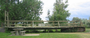
This
is a reconstruction of a small portion of that bridge. This replica is only showing
one section with one pier while the entire bridge consisted of 8 similar piers
that spanned the river to a rock outcrop on the north side.
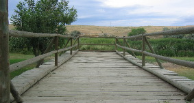
One
Oregon emigrant, John Murray, wrote on June 9, 1853: "The bridge is a substantial
structure-it has 8 wood framed piers filled and sunk with rock and the reaches
are supported by heavy braces. The sides are railed up and the bottom planked.
The bridge is about 150-yards long and comes out on the north side on a rocky
bank...at each end of the bridge are Indian lodges and trading houses and a blacksmiths
shop. Above the bridge about a mile is another trading post where they have lots
of horses and mules for sale or trade."
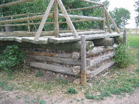
This
is a closeup of one of the 8 wood framed piers filled and sunk with rock. While
this "pier" is on dry ground now it was probably under water during
spring flood.
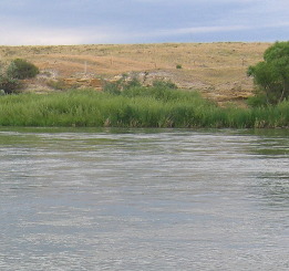
This
is the rock outcropping the north side of Richard's bridge was connected to.
The
Mormon companies that make the trek to to the Great Salt Lake Valley really captured
my attention. Some of these companies made the trip with hand-carts. Usually two
or three men would join forces with one hand cart to carry all their earthly posessions.
One or two would pull the cart while the other pushed. Food supplies and bedding
would be transported by Mormon wagons drawn by oxen. By using this method many
more emigrants were able to make the journey.
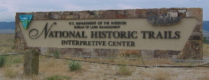
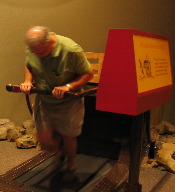
While
visiting the National Historic Trails Interpretive Center in Casper, Wyoming I
had a chance to experience pulling one of these carts. This was a diorama where
you could get on a tredmill and experience pulling one of those handcarts. A display
told you how fast you were pulling the cart in relation to how fast you would
have to go to make the required 15-miles per-day. I can guarantee you that there
were no "fat-boys" on that trip.
Another
display at the National Historic Trails Interpretive Center was their "register"
wall where a sampling of names & dates on register cliffs throughout Wyoming
have been duplicated. When I say duplicated I mean down to the color of the rock
the name & date is inscribed on. It is interesting to see these names and
dates on this wall without having to search through so many graffitti artist names
that have been added since the days of the great migration.
This
has been an awsome stop for us. I don't know how it could have been any better.
Until
next time remember how good life is.
Mike & Joyce Hendrix
