Places Visited: Idaho: American Falls & driving SR-39 from Blackfoot to American Falls along the west side of American Falls Reservoir then to Massacre Rocks & Register Rock State Parks 20-miles west of American Falls on I-86. July 25 & 26, 2006: Cowboy RV-Park in Pocatello, ID 208-232-4587 N42° 50.965' W112° 25.146 $26.25 Full hookups with 50-amps. Paved interior roads and pads. Very nice and clean park with an air conditioned laundry. Earlier this morning we visited the Potato Expo in Blackfoot. We really enjoyed touring that facility and reading all about potatoes. After finishing at the Potato Expo we decided to drive south to American Falls via SR-39 that follows the western shore of American Falls Reservoir.
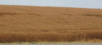
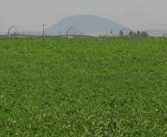
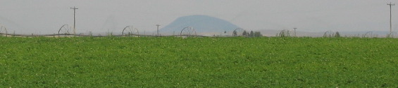
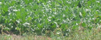
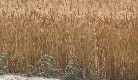
One thing we could see plenty of was grain fields (barley & wheat), potato fields and the occasional sugar beet acreage. To the west we can see the cones of ancient volcanos. The volcanos follow the great rift zone south out of Craters of the Moon National Monument.
Potatoes, sugar beets and ancient volcano cinder cones.
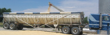
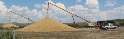
We stopped to watch this big 18-wheeler loading barley headed to the Budweiser brewery north of here in Idaho Falls. On the right one auger is removing barley from the storage facility while the other auger is delivering the same barley to the waiting trailer on that big 18-wheel rig.
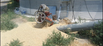
More pictures of the barley being moved from the silo to the truck. I found it interesting that so much of it was on the ground.
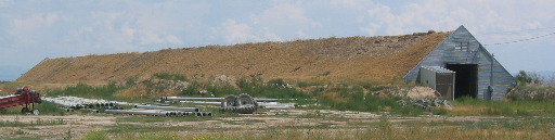
This is a potato storage facility. This is what they were like for years and years and some are still being used today.
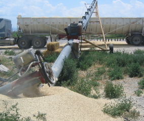
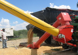
The harvester is harvesting white wheat according to one of the drivers delivering it to the storage facility.
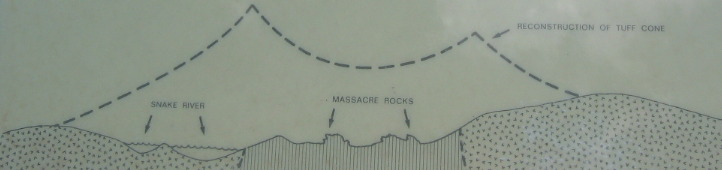
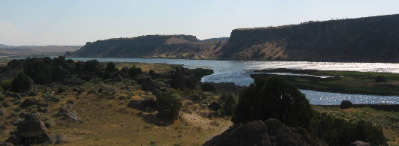
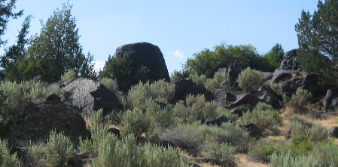
Actually, this was the storage facility. I asked why they were dumping it in this dirt parking lot instead of a silo. All the workers could tell was that this is where the boss said to put it. The person driving the truck did not know what they were hauling. I asked if it was barley or wheat and they had no idea. They were just paid to drive the truck from the field to this spot----not know anything about what was in the truck they were driving. Amazing but true. We were watching this grain activity on the southwest side of American Falls when we realized that we needed to "get-a-move-on" if we were to visit Massacre Rocks State Park and Register Rock today. These are two sites on the Oregon Trail that have special significance and we are trying our best to visit each of these places. They are located about 20-miles west of American Falls on I-86. Massacre Rocks got the name from an unfortunate incident when the native Indians decided enough White People had invaded their land. That is how it got the name Massacre Rocks but there is much more to this area than just that incident. When emigrants first took their wagons west from Fort Hall (you remember Fort Hall in Pocatella) in 1843, they soon encountered an unfriendly environment: desolation, suffocating dust, swarms of mosquitoes, hot days and cold nights. In many respects, the long trip across the Sanke River Plain would be the most difficult part of their journey. After reaching his destination in 1843, Jesse Looney wrote a letter to his brother-in-law in Illinois, Lt. John Charles Fremont carried the letter eastward to St. Louis for mailing. Mr. Looney noted: "Mrs. Looney says prepare yourselves with good strong clothing for the road or the wild sage will trip you. This shrub is very plentiful and was hard on our teams, especially those that went before, but it will not be so bad on those that come next year, for we have left a plain well beaten road all of the way." Peter Burnett was also among the first to take wagons past Fort Hall and wrote: "On 30th of August we quitted Fort Hall, many of our young men having left us with pack trains. Our route lay down the Sanke River for some distance. The road was rocky and rough, except in the dry valleys, and these were covered with a thick growth of sage or wormwood, which was from two to three feet high and offered a great obstruction to the first five or six wagons passing through it." On August 9, 1849, Major Osborne Cross commented on the prospect of traveling across the Snake River Plain: "The picture, on the whole, was anything but a pleasing one. When we reflected that we were to travel several hundred miles through a country presenting nothing more pleasing than barren hills and sterile plains having artemista (sagebrush) to burn, as well as food probably for the animals it was certainly discouraging." Dust and Mosquitoes made for harsh travel conditions and made life miserable even before emigrants reached the Snake River Plain in southern Idaho. The harshness and hardships emigrants endured in this area evoked many diary entries describing the hardships endured. "You in "The States'' know nothing about dust. It will fly so that you can hardly see the hornes of your tongue yoke of oxen. It often seems that the cattle must die for the want of breath, and then in our wagons, such a spectacle-beds, clothes, victuals and children, all completely covered." Mrs. Elizabeth Dixon Smith Geer August 29, 1848. Margaret Frink wrote on July 11, 1850: "Mosquitoes were as thick as flakes in a snowstorm. The poor horses whinned all night, from their bites, and in the morning the blood was streaming down their sides." Elizabeth Wood August 1851: Sometimes the dust is so great that the drivers cannot see their teams at all though the sun is shining brightly, and it is a great relief to the way worn traveler to meet with some mountain stream, meandering through a valley, after traveling for miles over these rough and dusty roads, through a country where every blade of grass has been dried up, with the drouth that generally prevails here at this time of year, except in the bottoms along the river banks, where we can yet get feed for our cattle." Myra F. Eells August 2, 1838: "Mosquitoes so troublesome that we can not get out of our tent without everything but our eyes covered; horses nearly black with them, and they cannot eat for them." Keep in mind that with the exception of young children and the ill, emigrants typically walked alongside the wagon. Westward-bound emigrants entered Idaho after crossing Thomas Fork Valley. They soon encountered the climb and descent of "Big Hill", witnessed nature's curiosities at Soda Springs, and discovered willing traders at Fort Hall. In 1843 wagons first rolled past Fort Hall to face the harshness and desolation of the Sanke River Plain. Dust, sagebrush, lava rock, mosquitoes, a burning sun, cold nights, and a concerned Native American population made the journey an arduous one. Yet, these pioneers continued on and helped to establish an ocean-to-ocean nation. Prior to the discovery of gold, California-bound emigrants followed the main Oregon Trail to Raft River before turning south on the California Trail. Gold seekers soon opened new routes in an attempt to reach their destinations sooner. Hudspeth's Cutoff (1849) directed traffic west from Soda Springs. The Salt Lake Alternate (Hensley's Cutoff) (1848) enabled travelers to obtain supplies in Salt Lake City before continuing their journey. These routes joined in the City of Rocks area and headed west through Granite Pass. As their numbers increased, lands along the trail became barren of grass and wood, and water sources often became tainted. Consequently alternate routes were explored and utilized. The South Alternate (1843); Northside Alternate (1840's); North Alternate (1850); Goodale's cutoff (1852); Lander Road (1858); and Keloton's Road (1869) all became heavily utilized by emigrants and early Idaho settlers. Prior to 1849, emigrants going to California shared the road with Oregon travelers until they reached Raft River. Here the trails parted. Those going to California turned south. In 1849, the California Trail intersected the newly opened Hudspeth's Cutoff at Cassia Creek and continued southwest. After leaving City of Rocks through Pinnacle Pass, the trail joined Samuel Hensley's Salt lake Cutoff, which opened in 1848, and continued southwest through Granite Pass into Nevada and on to California. After 1849 most California bound emigrants used Hudspeth's Cutoff rather than the Raft River route. Henry Tappan wrote about the "Parting of the Ways" in July 23, 1849: "At noon crossed Ford Creek & at night reached Raft River & camped. Grass good. At this point the two trails divide for California and Oregon. We met here quite a train taking the Oregon Trail, mostly families." Margaret A. Fink wrote on July 15, 1850: "...and in eight miles came to Raft River, a small stream that flowed from the mountains on our left. Here the roads fork again, the right-hand one turning off northwesterly towards Oregon, while we took the left hand one, going southwesterly towards California, leaving Snake River, and traveling up Raft River." The City of Rocks inspired all who viewed the wondrous rock formations, and emigrant diaries are filled with glowing descriptions of the area. Most emigrants who traveled through City of Rocks were headed for California, but some went to Oregon. In 1088 Congress designated City of Rocks as a National Reserve and directed the National Park Service to prepare a management plan. Then in 1996 management authority was transferred to Idaho State Department of Parks and Recreation. Vincent Geiger and Wakeman Brayarly wrote on July 19, 1849: "The road lies between high & immense rocky mountains, with not a particle of herbage or vegetation upon them, but being white & smooth upon their surface. Just opposite to where we encamped was one which struck us as particularly curious. It was a perfect face upon the highest cliff around. ...The road continued between these & around these rocky piles but the road itself was good. You can imagine among these massive piles, church domes, spires, pyramids, & in fact, with a little fancying you can see (anything) from the Capitol at Washington to a lowly thatched cottage. Four miles brought us to the coming in on the Mormon road. Half mile before striking it we passed through a narrow pass of rock, just wide enough for the wagons, & which evidently has been made by some adventurers before us." James F. Wilkins wrote on August 13, 1849: "We encamped at the city of rocks, a noted place from the granite rocks rising abruptly out of the ground. They are in a romantic valley clustered together which gives them the appearance of a city. I took several sketches of them. 5-miles from this comes I the new Mormon road which goes by the city of Salt Lake." The eroded volcanic landscape of Massacre Rocks State Park is part of the Snake River Plain--Yellowstone province, a belt of volcanic rocks that began to erupt about 15-million years ago and now stretches 400-miles from the Idaho-Oregon border to the Yellowstone Plateau. Volcanic tuffs exposed along the southern cliffs of the Snake River canyon record the oldest eruptions in the area of Massacre Rocks State Park. About 6.5-million years ago, volcanoes erupted from several vents in the area that is now Massacre Rocks State Park. At that time, rising magma (about 2,000-degrees F.) contacted shallow underground water of the Snake River Plain Aquifer, resulting in numerous steam explosions. The yellow-brown volcanic tuff that is exposed over much of the Park and especially near the Visitor Center is a product of these explosions. The tuff has many knobs and domes on its eroded surface, since it is more resistant to erosion where it locally has been cemented by the mineral calcite. It contains pieces of older volcanic and sedimentary rock that were ejected along with fresh lava bombs and ash. The original volcanic craters have been eroded away, but the dense lava plug that solidified within the throat of one volcano now forms the Massacre Rocks and nearby pinnacles. Later outporings of dark basalt lava now cover most of these ancient volcanoes, forming the broad expanse of the Snake River Plain. The canyon walls across the Snake River from Massacre Rocks State Park are composed of 75,000-year old basalt lava flows. The most recent outporings on the Snake River Plain occurred about 2,100 years ago along the Great Rift, a line of volcanic vents that begins 20-miles north of Massacre Rocks and extends northward for 60-miles into Craters of the Moon National Monument.
This is how the landscape looked 15-million years ago compared to today. I can understand geology so much better when geologist provide graphics like this. My mind just doesn't automatically understand how the landscape erodes and changes over 15-million years. Somehow, I am more attuned to things happening in less than 100 years.
A remarkable event occurred about 14,500 years ago when an estimated 1,000 cubic miles of water rushed north from Lake Bonneville, through Red Rock Pass, Marsh Valley, the Portneuf Narrows and Pocatello on its way to the Snake River and the Pacific Ocean. The flood probably lasted about eight weeks and was caused by the failure of a natural dam that lowered the level of Lake Bonneville by about 400 feet. It is the second largest flood known to have occurred in the history of the world and the estimated volume of water exceeds the total yearly discharge of all major rivers in North America. The Bonneville Flood greatly changed the Snake River valley, and its effects can be seen along the Snake River as scoured canyons and bars of watermelon-sized lava boulders occurring as far west as Hagerman, Idaho.
"Lake Channel" is a notch in the upper canyon wall on the opposite (north) side of the Snake River from Massacre Rocks State Park. This feature extends upstream nearly to the American Falls Reservoir and is one of several abandoned channels that were carved during the Bonneville Flood. Many of the autombile-sized, angular lava boulders within Massacre Rocks State park were moved during the great flood and are now 50-feet or more above the present river level. These pictures show that"notch" in the canyon wall. They were taken from Massacre Rocks State Park looking north across the Snake River.
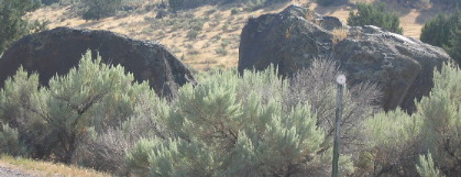
The Bonneville Flood deposited these boulders approximately 14,500 years ago. When the water broke through them with a tumbling action making them slightly rounded. They are located directly across from the notch where all that water poured through. You can see them when you visit Massacre Rocks State Park in Southeast Idaho 20-miles west of American Falls.
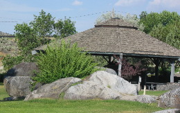
Only a few miles west of Massacre Rocks State Park is a neat place called Register Rock State Park. Although much smaller and unmanned the park preserves a really unique bit of Americana.
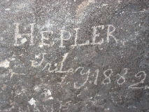
After their meals were cooked and their livestock grazed, early pioneers took time to record their presence on "Register Rock". The land around Register Rock was a common camping area along the Oregon and California trails. It is being preserved by the Idaho Department of Parks and Recreation so that modern visitors like us may enjoy a landmark of the past. Unlike other "register rocks" on the Oregon Trail this rock is a bit better preserved in my opinion. Most of the names and dates are from the mid-late 1800's. Idaho has done a good job of preserving "Register Rock". It is located under that covered building and is protected by a chain link fence to keep "modern" graffiti artists from adding their names.
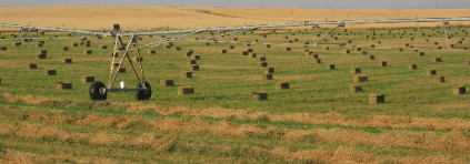
On our way back to Pocatello we passed this hay field near American Falls.
If you ever find yourself in southeast Idaho on I-86 a short stop by Massacre Rocks State Park and Register Rock, you will be glad you did. Until next time remember how good life is. Mike & Joyce Hendrix
|
| ||