|
Kentucky: Land Between the Lakes, Grand Rivers, Paducah Illinois, Metropolis & Superman, Fort Massac State Park Places Visited: Kentucky: Land Between the Lakes, Grand Rivers, Paducah Illinois, Metropolis & Superman, Fort Massac State Park. Thursday July 15, 2004 We put Louisville in our rear view mirror this morning. We were headed to LBL or Land Between the Lakes, Kentucky. We have never visited the LBL area but a number of friends have and really like the area. Besides we have friends from Pensacola staying at a PPA (Pass Port America) campground on Kentucky Lake just west of the Tennessee river or Kentucky Lake from LBL. Thanks to Barry on the RV-newsgroup for reinforcing our decision to stay at the COE Campground in Grand Lakes the small community at the north entrance to LBL. I knew the COE campground was there because others had recommended it but Barry was the first one to provide GPS coordinates. With Barry's coordinates we didn't even slow down on the way to the campground. Joyce put them into our SA-2004 mapping program and bingo we followed the route directly to the park. I guess we could have gone directly to the site that Barry was on but the attendant gave us another site. Barry has a few years on me and has one of those Golden Age Passports that get him National Park & COE campground spots for ½ price. While $20 is cheap for a lake front site with a 50-amp connection Barry stayed in a site away from the water for only $8.50 with his "Golden Age Card" ($17.00 for us youngsters). Deals like the Golden Age Card make getting old seem worth it. Within a mater of minutes we had the motorhome set up and off we went in the Saturn to take in LBL. The Land Between the Lakes has always been here but before the Corps of Engineers constructed Dams on the Tennessee River and Cumberland River the area was known as the "Land Between the Rivers". It was also a great divide. The ridge of limestone known as the Tennessee Divide split the watershed between the Cumberland River on the east and the Tennessee River on the West. The Cumberland and Tennessee Rivers flow northward side by side for a hundred miles framing what was know as Between the Rivers. This "Divide" or high ridge of limestone runs the length of the area and a "Trace" runs down that backbone or divide. If by chance you start looking for "The Trace" it is SR-453 essentially going south out of Lake City, Kentucky.
In bygone days, a "Trace" was a trail through the wilderness beaten down by the passage of animals or people. In the 18th and early 19th centuries, when large animals like elk and bison were still common in some parts of the country, they created "traces" that sometimes evolved into roads traveled by humans. LBL "trace" is NOT one of those timeworn paths, but the name is a reminder that this land was once home to wildlife that are now seldom seen in the in the eastern portion of the United States. The Trace is the major north-south route in LBL. The "Trace" follows the boundary of the historic Sycamore Shoals treaty, signed by Colonel Richard Henderson and the Cherokees in 1775. Water related activities are the big attraction to the area but various and sundry activities are available. LBL features an Elk & Bison Prairie which is a 700-acre restoration of Kentucky's native barrens. While both elk and bison were once plentiful in this area hunters had virtually eliminated all buffalo in Kentucky by 1800 and elk were eliminated not long after that. To give you a mindset of the settlers back then as elk became more scarce, poachers competed for the honor of being the last person in their district to kill one. Many of the local histories published in the late 19th century proudly touted individuals who had shot the last elk in their community. By the 1820's elk were seldom seen anywhere in Kentucky or Tennessee. Prior to the white man arriving in the area Native Indians would set fires to the prairie lands every year so that the prairies would remain and the elk & bison would have grazing areas. Without those annual burns hardwood forests took over, crowding out native grasses. We took a drive through this prairie around 3:30 in the afternoon and only saw a few elk but did see an entire herd of bison. Elk usually bed down in the shade during the heat of the day so not seeing many of them was expected. The bison we saw were gathered near a pond yet in a dry sandy spot. They were wallowing and rolling in the sand and dirt. Dust was flying; it must have felt good because they appeared to be enjoying themselves. We stopped by the LBL Visitor's Center where we watched some movies and read about the history of the area and how area residents were moved/relocated when LBL was created. It was in the Visitors Center that I read about the explanation of the LBL area as the Kentucky Divide. Joyce and I are familiar with the Continental Divide and a "divide" that runs north & south in Texas, Edwards Plateau, that divides the moisture flow to the east and west with all westward flow going into the Pecos River. Now we are learning of the Kentucky Divide that divides water flow to the Tennessee River on the west and the Cumberland River on the east. As bad as I want rivers to flow to the south both the Tennessee River and the Cumberland River flow north into the Ohio River just upstream from Paducah, Kentucky.
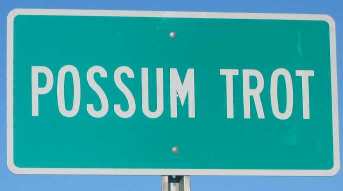
In one of the campgrounds in the park they are having a rodeo Friday and Saturday nights. That campground has horses and stables, with horses for rent or you can bring your own. I think that campground had 170 sites. The LBL area is literally crawling with campsites. State parks ring the outside borders both lakes. Each of these state parks offer camping and a host of other activities especially water related activities. To cap off our day we stopped by to see Fred & Nancy Kelly friends of ours from my work days at the Navy Base in Pensacola. Fred & Nancy both worked at the Depot in Pensacola. Fred said that he took advantage of an early-out opportunity and retired in 1993. Nancy was a machinist; she didn't say when she retired. They are doing volunteer church work this summer helping a small church near their park with some construction. It seems that both Fred & Nancy are skilled at sheetrock finishing. Someone in the church is installing the sheetrock in their spare time. Fred and Nancy stop by and put the finishing work on it. Other than that Nancy is piddling and Fred is fishing. Joyce and I visited their place and got a look at the boat Fred is fishing in every day. Three couples, all Fred's fishing cronies, were at a picnic table eating "filets of brim" and other "fixins" (southern term). The only reason Fred & Nancy weren't at the table was because they were going out to eat with Joyce and I. The eating party opened the "goody-bag" and I got a handful of those crispy brim filets". Yummy! We were going to have to eat good to beat that. Well, eat good we did. When visiting Land Between the Lakes RV'ers have long recommended "The Iron Kettle" restaurant, in Grand Rivers, as a "must-do" dining experience so that is where we ate. We are now going to add our voices to the legions singing The Iron Kettle's praises. Their good home cooking was just that. It was like sitting down to grandma's Thanksgiving dinner. After dinner Fred & Nancy stopped by our place to see Canal COE campground where we are staying, to check the facilities out, before heading back to their place. It is always good to spend time with friends. As we pulled into our camp site next to the water we were introduced to a mayfly hatch. We do not have mayflies in Florida to my knowledge. I know that fly fishermen tie flies to look like mayflies and I have heard that fishermen want to tie flies that duplicate the different particular hatches. I now have more appreciation for what a "mayfly-hatch" is. As I pulled into our site it created excitement in the trees and thousands upon thousands of mayflies filled the air. I don't think I have ever seen gnats that thick and in that number. Joyce and I gawked at this spectacle for a while then went on about setting up and heading out. When we returned to the motorhome about 8PM the side of the motorhome was covered with mayflies. Upon inspection many had wings while others did not. When we touched the ones without wings we found that it was only a skin. The mayflies from our arrival had molted and left behind their old skin. I guess that the mayflies with wings hanging on the motorhome are doing the same thing. As the sun went down we looked outside and the mayflies were even thicker than before. We went outside to see this phenomenon first hand. I suppose the "hatch" we saw when we arrived was the opening round and this was the finale. It is totally impossible to describe how many mayflies were in the air. The lake for acres and acres around this hatch was a mass of feeding fish. We noticed that while many flies were falling in the water many others were heading to the heavens above. Those may have been attracted to the remaining light high in the sky. Whatever, the mass of insects were rising and slowly spiraling into the dwindling light. Friday July 16, 2004 Joyce had planned a day jam packed with activity. This was our day to visit Paducah, Kentucky. Paducah is located about 20-miles from Canal Campground at LBL so we had a little drive. On our way over we passed through the community of Possum Trot.
Possum Trot, Kentucky
It doesn't take much to amuse the two of us and that sign did it. I wheeled around to take a picture of that sign for the sign collection on my web site. I can just imagine the conversation between two strangers----Hi! Where are you from? Well there, funny you should ask, the wife and I we call Possum Trot home. And where might you be from?
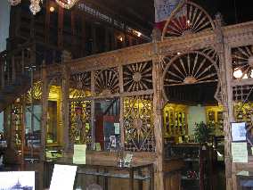
Joyce's first stop was the Museum of the American Quilter's Society. This wasn't one that I was jumping for joy about. However, the joke was on me. The museum was great. I thoroughly enjoyed myself and came away from the museum with a much deeper appreciation for quilting. Over the years I have come to think of quilts as a patchwork of squares sewn together. Those multi colored squares just did not really interest me. The quilter's Museum has taken quilts to a level that leaves multi-colored square things back in the stone ages. I could not help but marvel at the artistry of the varied quilts on display in the three galleries. Joyce kept saying that she thinks of Karen Williamson and Kathryn our DIL when she thinks of quilting. Kathryn gave Joyce a prized quilt for her birthday just before we left on this trip. I would like to be able to describe the quilts on display but it is beyond my vocabulary. Suffice it to say that these folks weren't into stitching together squares. Men, some advice, don't squall if your spouse wants to visit the Quilter's Museum in Paducah. You will enjoy the time you spend there, trust me on this one. Our next stop was the William Clark Market House Square Museum. Paducah was founded in 1827 by William Clark of the Lewis & Clark expedition fame. The historic river town's prosperity can be contributed to its location at the confluence of the Ohio and Tennessee Rivers. Market House Square is the area William Clark designated for public activity. The 1905 brick Market House remains the heart of downtown and houses the Market House Museum.
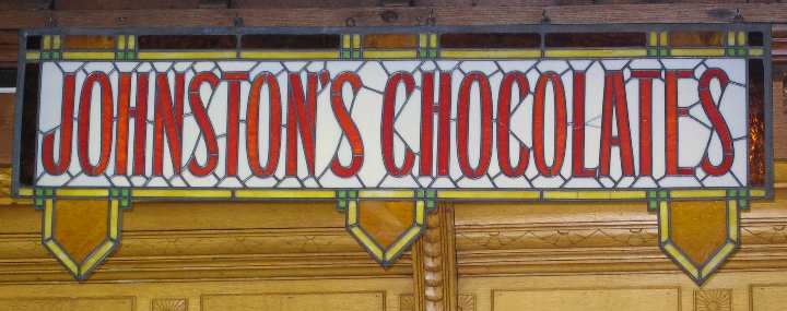
Johnston's Chocolates sign seen in Paducah, Kentucky
Market House Museum in Paducah, Kentucky
The log Market House structure from the mid1800s was replaced with this brick structure in 1905. Inside the museum you get a glimpse of Paducah's rich heritage and colorful past. The most imposing exhibit is the complete interior of Paducah's List Drug Store, which has been relocated to the Market House Museum. Ornate "gingerbread" woodwork handcrafted of oak by artisans whose work is almost a lost art today.
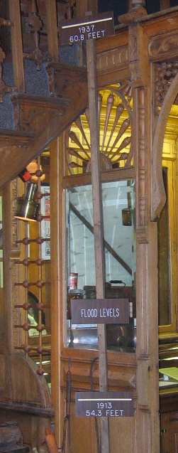
Marker for the "Super Flood" of 1937 in downtown Paducah, Kentucky
The "Super Flood" of 1937 is depicted in many photos and a prominent measuring stick showing where the flood level reached 60' above flood stage and where it was over the floor of the second story floor in the building. To comprehend that flood was beyond me. Here we were in a building constructed on a hill 50' above the river and they are showing the mark of a flood that rose to 54.3' in 1913 then my eyes shifted up the marker board to where the water came in 1937 when it rose to 60.8'. There are pictures of people in boats crawling in 2nd story windows. Totally incomprehensible!
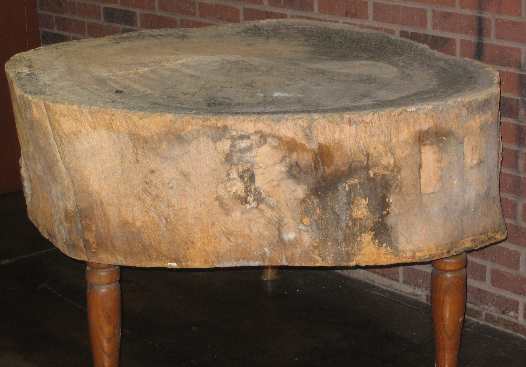
Chopping block or butcher block on display in Paducah, Kentucky Museum
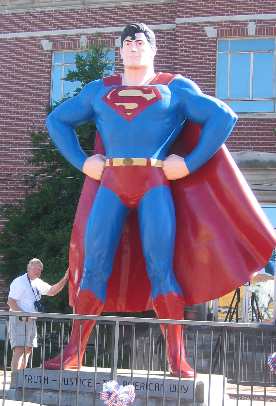
I was particularly intrigued by a chopping block made from an ancient tree trunk cut crosswise like a log. This trunk was a good 4' in diameter. An elderly lady in the museum said that she remembered butchers in the market plying their trade on that very butchers block when she was a child. No one in the museum knew what kind of tree the butcher block log was from. This is another museum that would make a good stop for anyone visiting Paducah. As soon as we exited the Market House Square Museum Joyce trotted me around the corner to the River Heritage Museum located in Paducah's oldest building. This was a truly outstanding museum and must do if you visit Paducah. The museum is geared toward people of all ages; from young kids to retirees. It covers from the earliest days when Indians plied the river, to the present. What impressed me most about this museum was the number of dioramas in the form of water-filled displays. One was a lock and dam model where you could be the operator and open the lock door allowing the toy tug boat barges to enter the lock. Safely inside it was time to close the gate and open the valve letting water enter the lock. Once the water level reached the level of the next body of water it was time to shut the valve and open the gate so the tug and barges could continue on their journey. It was a really educational exhibit. Words don't come to mind to adequately describe one diorama where a relief map is presented to show the drainage of the Ohio River system including the Tennessee and Cumberland Rivers. Of course the relief map depicts the slope of the Ohio River drainage system with the highest part of the relief being in Pennsylvania and Ohio and northern Indiana and Illinois. And Tennessee and Kentucky both drain toward the Ohio River via the Green, Cumberland and Tennessee Rivers. The diorama was showing what happened in the great flood of 1937. Water sprinklers from above the relief map rained on the country side. The diorama explained how rain starting in January and continuing into February over the entire drainage of the Ohio resulted in the flood of 1937. Watching the sprinklers deliver rain day after day we could see the flood waters build and build day by day. The rivers were soon not able to handle the drainage and water started to back up until at it's worst water was 60' above flood stage in Paducah. We all know that water flows downhill, or at least we should. What I liked about this exhibit was how this relief map had the elevation of the eastern United States presented complete with rain falling and flowing into the rivers and the rivers flowing into the Ohio and in turn the Ohio down to the Mississippi. The Tennessee, Cumberland and Green were flowing out of Tennessee and Kentucky emptying into the Ohio which in turn emptied into the Mississippi not far downstream from Paducah, and of course the Mississippi was delivering water to the Gulf of Mexico. Knowing water thus rivers flow downhill is one thing seeing it in action is powerful. Another exhibit with running water was the diorama of the electric power generating plant on the Cumberland River not far from our campground. We could see the turbine spinning in a clear raceway as water raced past it from the dam to the spillway behind the dam. Again this was a powerful demonstration for both adults and children. A good movie was shown in the theatre that covered a variety of aspects of commercial activity on the river. In another exhibit a dredge was removing sand and gravel from the river bottom that would be used in the construction industry. To say I was impressed by the ingenuity involved in presenting this information would be an understatement. This is one of the very best museums we have ever been in. Don't pass this one by if you are in the area. Paducah's history is sublimely captured in over 30 artistic renderings by internationally know muralist, Robert Dafford, and his team of artists, on Paducah's floodwall. These murals are absolutely awesome. The coloring, the quality, and the subjects everything is outstanding. Each panel depicts an important event in Paducah's history. In front of each mural is a bronze plaque that provides a short synopsis of what is being presented. We have seen some of Robert Safford's work on buildings in Cajun Louisiana towns like Jennings and Raines. Robert and his team are from Lafayette, Louisiana. This series of paintings on the retaining wall is the most impressive yet. Although we did not see Robert's name on them the murals we saw on the retaining wall in Vicksburg I will bet that he did those also. Superman on display in Metropolis, Illinois
It was now time for us to drive across the river to Metropolis. Think about it for a moment. What are we going to do in Metropolis? Come on now, it is home to none other than Superman. We couldn't be this close and not stop by Metropolis and visit with Superman. There is a museum and other things but we settled for just getting a few pictures to say we had seen this and done that. The picture to the left is of course Superman with yourstruly tugging on Superman's cape. That just seemed appropriate since those of you that are friends from my working days know that I have an "irresistable penchant" for "Tugging on Superman's cape". So I dedicate this pic to all my friends from my working days. I am only pulling on the Superman from Metropolis's cape these days. VBG (Very Big Grin) The thought occurred to me that Superman fromn Metropolis didn't respond anything like those in the "good old days".
As we left Metropolis Joyce looked up and said "we missed something back in Metropolis". She had been reading a tourist tract on Metropolis so I asked "What did we miss?" The Bird Man of Alcatraz is buried here. Whew! For a moment there I thought we might have missed something
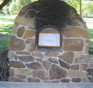
On the way out of Metropolis we stopped by Fort Massac State Park. Fort Massac was a fort built in the mid 1700s by the French to keep the British from this part of the interior. It was later used as protection from the Native Indians. George Washington ordered it to be rebuilt. George Rogers Clark moved through here during the Revolutionary War when he expelled the British from "The North West Territory" which is what Illinois and Indiana was called back then. Lewis & Clark Camped at Fort Massac on November 11, 1803 a few days into their epic journey to the west Coast. Community oven onexhibit at Fort Massac State Park in Illinois
An exhibit at Fort Massac caught my eye and imagination. It was a "community" oven. The community oven would be used to bake bread for several families. Women would make their bread dough at home and bring it to the oven on a morning to bake bread and visit with her neighbors. To warm the oven a fire was made in the oven and heated for several hours. The fire was then removed and the floor swept clean. Meal or flower was then thrown on the floor and the bread dough would be placed on the meal or flower on the oven floor. A large wooden or iron door would seal the opening while the bead baked. If you want to see this oven you will have to wait until I post this travelogue to my website. For those of you that are interested Fort Massac State Park has a nice shaded campground. We drove through it and saw what appeared to be 30 to 40 sites with 30amps and water. A central dump station was available. It was 7PM by the time we got back to Grand Rivers and it was time to stop by the Iron Kettle for dinner. Tonight they featured buffalo pot roast. It was out of this world as was the catfish according to Joyce.
Click here for more Kentucky travellogsUntil next time remember how good life is. More Illinois AdventuresAdventures by State ** 2004 Travel Adventures
Mike & Joyce Hendrix
Mike & Joyce Hendrix who we are We hope you liked this page. If you do you might be interested in some of our other Travel Adventures: Mike & Joyce Hendrix's home page Travel Adventures by Year ** Travel Adventures by State ** Plants ** Marine-Boats ** Geology ** Exciting Drives ** Cute Signs ** RV Subjects ** Miscellaneous Subjects
We would love to hear from you......just put "info" in the place of "FAKE" in this address: FAKE@travellogs.us Until next time remember how good life is.
|
| ||
|
| |||
|
| |||
|
|