Yellowstone National Park GeologyAug 1-4, 2007. We are staying in Grizzly RV-Park in West Yellowstone, Montana just out the west gate of Yellowstone National Park. We stayed in a different site every night because we did not have reservations and at this time of year they are FULL. The only way we got to stay there for 4-nights was to move into cancellation sites. The rates range from around $37 to $47 depending on a variety of things but generally back in sites were cheaper than pull-thru sites. Then they charge $4 for wifi. I suppose the pull-thru sites are a bit larger so the BIG rigs would probably be forced into one of them. Grizzly is a nice park, the nicest campground in the area. Bottom line is if you are planning to visit WEST YELLOWSTONE during July thru Aug-15 you need a reservation as every campground in the area is FULL. After August 15 you can have your choice of campgrounds with no reservations.
Yellowstone National Park is one of the world's largest, most explosive, and most unusual volcanoes. The molten rock several miles beneath Yellowstone affects everything in the park---the landscape, the wildlife, and even the climate.
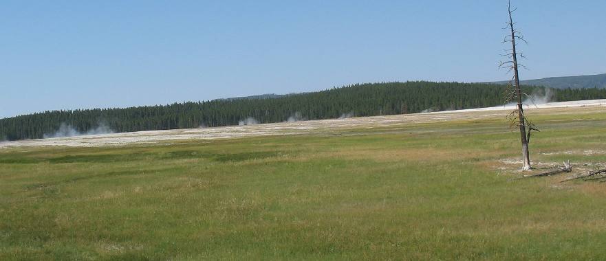
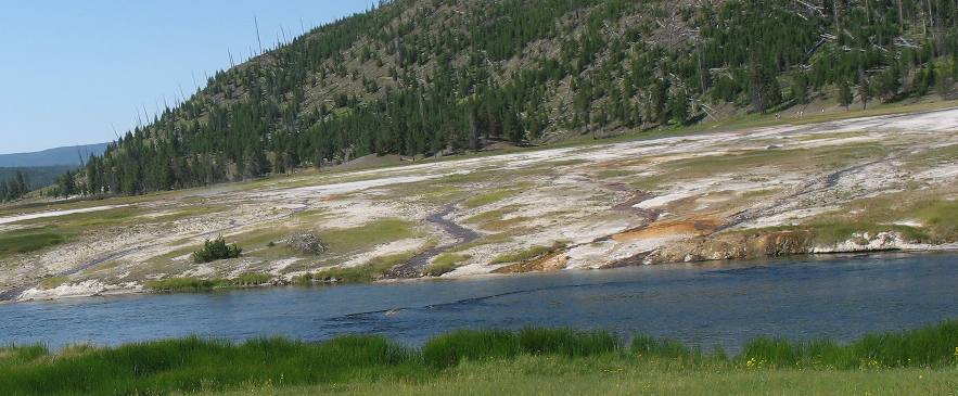
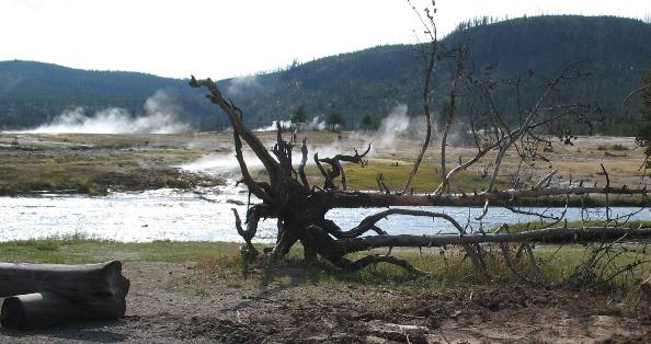
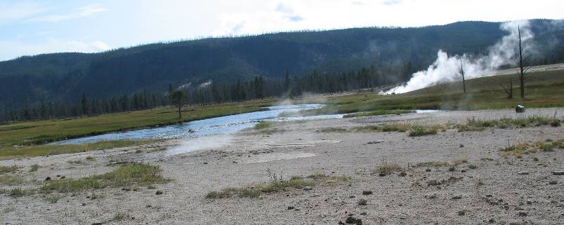
Lower Geyser Basin
This is Lower Geyser Basin located on the Grand Loop Road between Old Faithful and Madison Junction.
Both sides of the road between Old Faithful and Madison Junction are covered with thermal activity. A geyser is a type of hot spring that tosses hot water into the air. Throughout Yellowstone there are four types of thermal features to look for: geysers, hot springs, fumaroles, and mud pots. I will try and explain the differences as we get to them.
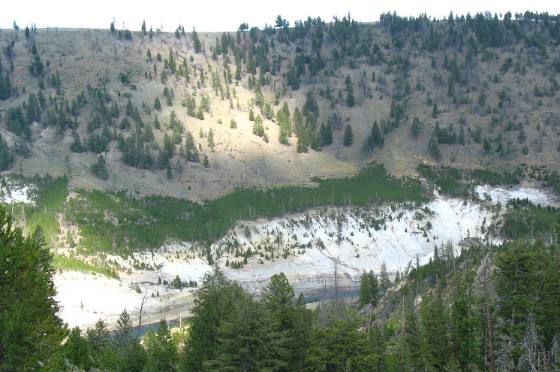
Lower Geyser Basin
Joyce took this picture from Grand Loop Road looking to the west. For those with more time and interest roads go back into this area so you can inspect these geological creations up close, via walkways. This looks to be an area of hot springs and geysers.
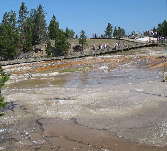
Biscuit Basin
This is just north of Old Faithful and as you can see walkways are constructed so you can get a close look at these geo-thermal springs. I think this is what they call Biscuit Basin.
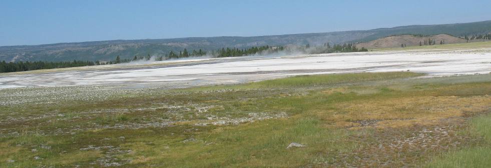
Upper Geyser Basin
This is in the Upper Geysers Basin and only a mile or so north of Old Faithful. Super hot, mineral laden, water has left behind this thick deposit of minerals. As you can see some of the water makes it to the Fire Hole River. The Fire Hole River gets its name because it flows through this "fire hole". There must be 5 or more miles of thermal activity, similar to this, along this section of the river.
Firehole River & thermal activity
Different minerals provide different colors. Again this is the Fire Hole River.
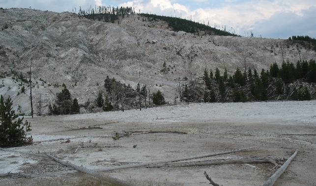
Roaring Mountain
This is Roaring Mountain. It is a living landscape. Amid Roaring Mountain's steam and sulfur-rich gases, microscopic organisms are hard at work. This barren slope, inhospitable to humans, is the perfect home for billions upon billions of thermophiles that live here, wearing away the mountain.
Roaring Mountain was named for the sound of steam fumaroles that became very active and noisy in 1902, killing a mountainside of trees. The activity subsided in the 1920s and has been relatively quiet ever since. The acidic pool near the road is called Lemonade Pond. Ground heat and acid prevent trees from growing in much of the area. Fumaroles are holes in a volcanic region from which hot gases and vapors issue. Hot gasses and vapors are the trademark of fumaroles. Fumaroles are also referred to as steam vents. In simplest terms, a fumarole is a vent in the Earth's crust. The supply of water around a fumarole is not as plentiful as in hot springs and geysers. Modest amounts of groundwater come into contact with hot rocks underground and are turned to steam. This steam rushes up through a series of cracks and fissures and out the vent, sometimes with enough force to create a loud hiss or roar. Roaring Mountain can be seen from Grand Loop Road between Norris and Mammoth (the northwest side of Yellowstone).
Madison Plateau lava flow rising above the Madison River
The Madison River on the west side of Yellowstone flows between thousand foot high walls of the Madison Plateau, which oozed thick and viscous after the eruption and collapse of the great Yellowstone caldera, 600,000 years ago. Generally, in central Yellowstone forest cover the lava flows, while meadows cover the sand and gravel left by glaciers in the low places (ie. in the valleys and river bottoms) between the lava flows. All the rock you see in this picture is a giant lava flow.
Yellowstone does not look like a familiar cone shaped volcano. However, a volcano is any place where molten rock, called magma, rises from within the Earth and erupts onto the surface. Yellowstone's three caldera eruptions were devastating. The smallest of those eruptions was 280 times larger than the 1980 eruption of Mount St. Helens. During that recent eruption, ash and rock were hurled at hurricane speeds, mudflows were triggered that traveled up to 90 miles per hour, and powerful winds snapped giant trees like matchsticks.
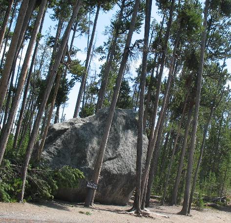
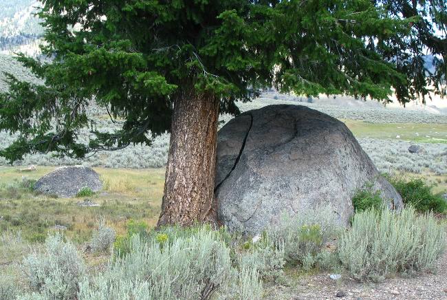
Glacial Erratic
Not all geology in Yellowstone was created by volcanic activity. This is a large glacial erratic dropped here by a glacier thousands of years ago. This large boulder is of different material than the surrounding rocks. It was transported here by a glacier that melted thus releasing this "rock" here, far away from where it originated. It is 15-miles from its nearest place of origin. It was dropped from melting ice (the glacier) about 10,000 years ago.
By the way you can see this large (estimated to weigh 500-tons) " glacial erratic" or "glacial boulder" on the road from Canyon Visitor Center to Inspiration Point.
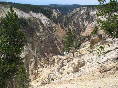
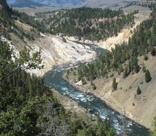
Grand Canyon of the Yellowstone
This is looking into the Grand Canyon of the Yellowstone.
Measuring 1,200 feet at its deepest point, 4,000 feet across and 24 miles long, the canyon is basically a river eroded geyser basin. Hot acidic water from numerous hot springs in the canyon have weakened the volcanic rocks here, making them vulnerable to rapid erosion and allowing the creation of a fast-expanding canyon.
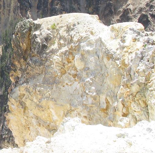
Hydrothermically altered rock
This is a close-up of that volcanic rock (most likely rhyolite) that has been altered and weakened by the hot acidic water from the hot springs (hydrothermically altered rock is the result). I think this would fit into the category of metamorphic rock since it is a changed igneous rock. How about that for remembering some earth science from high school, or was it middle school, when we learned about the three types of rocks, igneous, sedimentary and metamorphic. It has been a LOOOOONG time! Amen.
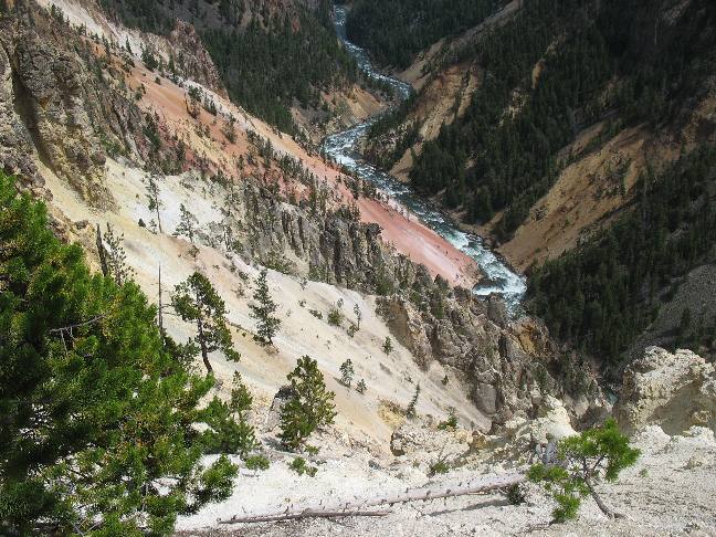
Grand Canyon of the Yellsowstone
This is again looking down into the Grand Canyon of the Yellowstone. This is where the Yellowstone River got its name.
Yellow mineral patches on the canyon walls indicate hot springs and fissures. Even a minor tremor can trigger a landslide from these thermally weakened cliffs.
Biscuit Basin and Fire Hole River
This picture is from the Biscuit Basin area along the Fire Hole river near Old Faithful.
These are hot springs that you see. Some of them may possibly be classified as fumaroles but from the volume of water these appear to be mostly hot springs. Hot springs tend to let off enough heat by boiling or surface evaporation to avoid the kind of steam explosions common to geysers. Some of the hot springs will take the form of hot pools.
Geyser & hot spring
A geyser is a hot spring with the intriguing habit of tossing underground water into the air. When water falling as rain or snow seeps through porous layers of rock eventually that water comes into contact with extremely hot rocks. This hot water then rises through a series of cracks and fissures underneath the surface of the Earth. You can think of these cracks and fissures underneath the surface of the Earth as a "plumbing system" of a thermal feature such as a geyser. A geyser is the equivalent of a giant pressure cooker, even though the temperature of water deep down may be well above boiling, the weight and pressure of the water above prevents that boiling from happening. Eventually, though, the pressure builds enough to push the water in the upper reaches up and out, causing an overflow. That overflow, in turn, relieves the pressure on the super-heated water below, causing it to flash into steam. That flash, that explosion through a narrow, constricted place in the rocks, is what sends water shooting into the air. And that folks, is a geyser in a nutshell. VBG
Yellowstone Caldera
The distant ridgeline is the rim of a huge crater. Here a huge volcanic eruption blew cubic miles of glassy material into the atmosphere --- remnants carried as far as Texas and California --- then the crust collapsed, forming a caldera or basin. Though a catastrophe 600,000 years ago seems unimaginably remote, subsurface activity has been ongoing and will happen again.
Bare patches in the forest like the one in this picture reveal hot springs or fumaroles, where superheated water boils up along fracture lines. The ground around some of the hot springs is unstable---geologist have fallen through the crust and suffered serious burns. Sulfuric acid in the area of these springs can burn through clothing.
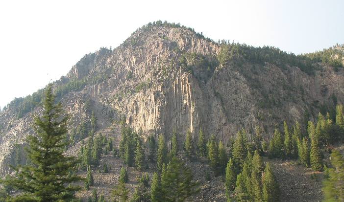
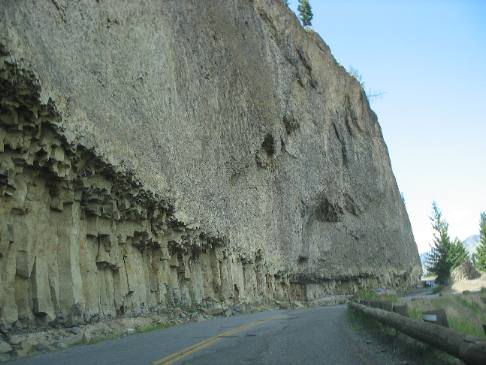
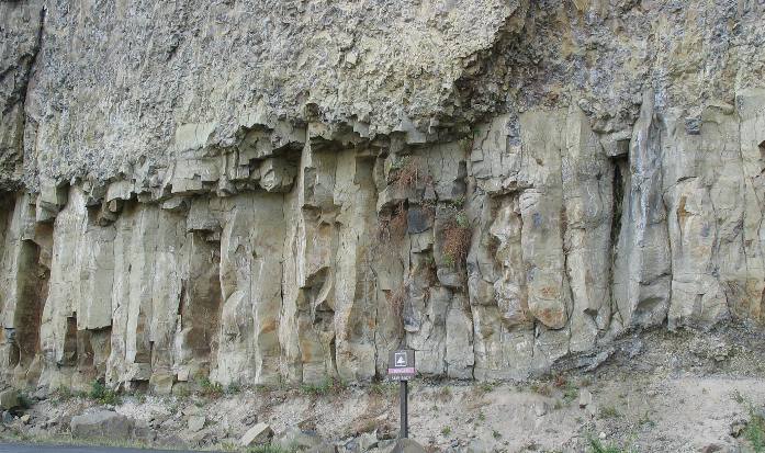
Basalt from a lava flow
This solid basalt cliff hugs Grand Loop Road in the northeastern part of the park. This basalt was formed from a lava flow.
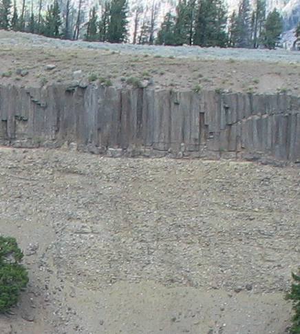
Columnar Basalt
The speed with which lava cools can determine the type of rock that is formed. In this instance the cooling lava has formed columnar basalt.
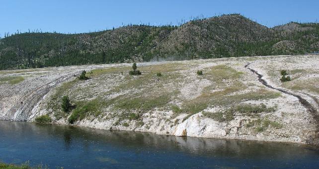
Calcite Springs
In cool weather, wisps of steam rise from Calcite Springs---the pale slope near the river. There the Yellowstone River flows above a volcanic fracture zone that allows geothermal discharge to reach the surface. Chemicals from Calcite Springs' hot water vents are slowly turning the cliff to whitish, yellowish pulp.
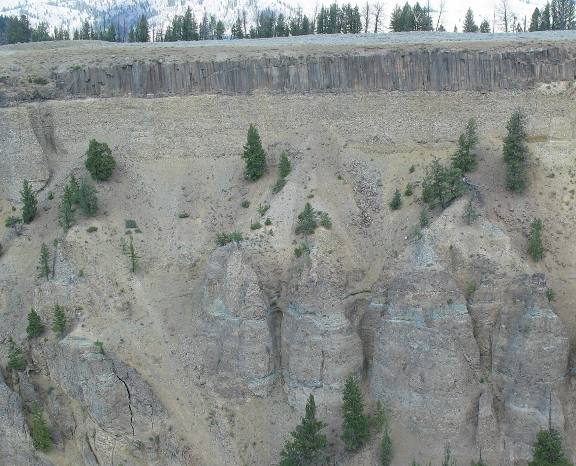
Columnar basalt cap rock protecting a thick layer of glacial moraine
The cliff wall on the other side of the Yellowstone River near Tower Falls has some interesting geology. A thick layer of columnar basalt provides a cap over an even thicker layer of glacial moraine (river rock or cobblestones if you will) that appears to be around 50 feet thick.
Glacial moraine covered by a thick layer of columnar basalt
This is a closer look at the thick layer of glacial moraine covered by that thick layer of columnar basalt.
A kiosk indicated that the lava flow across the river is 25 feet deep and was deposited 1.3 million years ago. The kiosk indicates there is a loose mix of gravel (river rock/cobblestones) carried here by glacial melt water on top of the columnar basalt. I can see earth on top of the basalt layer but I can not identify it as cobblestones from this distance. If that be the case then the deep deposit of glacial debris was in place before the lava welled up and flowed over the debris field. Then another glacier formed and deposited yet another layer of glacial debris on top.
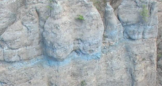
Possibly Hydrothermically altered rock
Further down the canyon wall is this layer of turquoise colored sedimentary rock. While I can follow this layer of sedimentary rock for approximately one half mile only certain sections have turned this turquoise color. The remainder is just a lighter color gray. I suspect that acidic steam from a fumeral has something to do with this change but certainly have no knowledge of that.
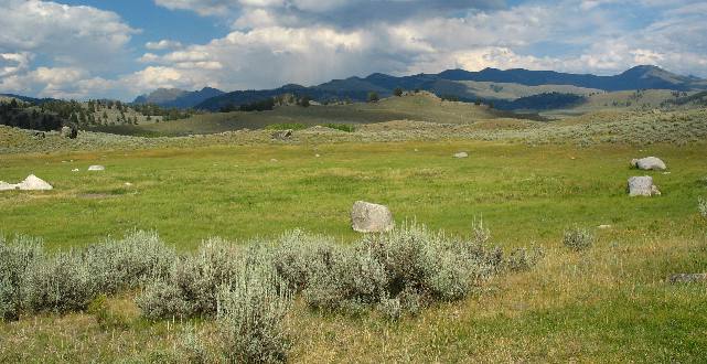
Between Roosevelt Junction and the Lamar Valley lies an interesting geologic area that provides abundant evidence of the glaciers that once covered this area.
Glacial erratics
These large boulders are glacial erratics.
Far from their origins, these giant boulders were carried by ice for many miles before being abandoned and dropped by the melting glacier.
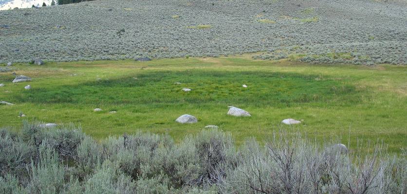
Evidence of ancient glacier
This scene is evidence of a long gone glacier.
After carving the mountains and valleys a once powerful glacier melted and retreated, leaving clues of its existence like scattered kettle ponds (this green depression is a kettle pond), ground moraines, and isolated boulders (glacial erratics). Born during the glacier's retreat, kettle ponds are now home to many plants and animals. As geologists tell time, the last glacier retreated from here around 12,000 years ago.
Kettle Ponds
As a glacier recedes, house-sized blocks of ice are sometimes left behind, partially buried in ground-up rock and soil. Although insulated by glacial silt, the ice gradually melts, leaving a steep-sided or kettle-shaped depression that can later fill with water and form a pond.
The large boulders seen strewn about are glacial erratics.
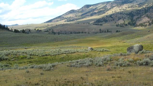
Kettle pond & glacial erratics
This is another kettle pond although it is harder to distinguish.
The large boulders are glacial erratics.
Geothermal activity along the Yellowstone River
Here the Yellowstone River is again flowing above a volcanic fracture zone that is allowing geothermal discharge to reach the surface. Chemicals from hot water vents along the river are slowly turning the cliff to whitish, yellowish pulp. The area most likely is composed of a high degree of sulfuric acid.
More Montana AdventuresSome Exciting Drives** More 2007 Travel Adventures
Mike & Joyce Hendrix
Mike & Joyce Hendrix who we are We hope you liked this page. If you do you might be interested in some of our other Travel Adventures: Mike & Joyce Hendrix's home page Travel Adventures by Year ** Travel Adventures by State ** Plants ** Marine-Boats ** Geology ** Exciting Drives ** Cute Signs ** RV Subjects ** Miscellaneous Subjects
We would love to hear from you......just put "info" in the place of "FAKE" in this address: FAKE@travellogs.us Until next time remember how good life is.
|
| ||

| |||
|
|
|||
|
| |||
|
|